Page 180 of 276
Re: FORGOTTEN CORNERS
Posted: 03 Jun 2020, 10:44
by Christian
Here are a few of Carleton in Craven. Mainly focused on the earthworks at the rear of the church, in line with the present "Old Hall"
ca1.jpg
ca2.jpg
ca3.jpg
Will be taking some closer ones once all livestock is back indoors.
Re: FORGOTTEN CORNERS
Posted: 03 Jun 2020, 15:25
by Sue
Doing some genealogy. Where were/are Monk House Cottages, Barnoldswick, birth circa 1860 as a clue perhaps
Re: FORGOTTEN CORNERS
Posted: 03 Jun 2020, 15:47
by Big Kev
Sue wrote: ↑03 Jun 2020, 15:25
Doing some genealogy. Where were/are Monk House Cottages, Barnoldswick, birth circa 1860 as a clue perhaps
https://www.rightmove.co.uk/sold-prices ... 60319.html
Re: FORGOTTEN CORNERS
Posted: 03 Jun 2020, 15:50
by Sue
Thanks Kev, still there then. I have a DNA match with someone who has an Isabelle Harrison of this address in their tree. i have a Betty Harrison a bit further back who married in St Mary the Ghyll, I can do a bit of chasing back now
Re: FORGOTTEN CORNERS
Posted: 03 Jun 2020, 16:42
by plaques
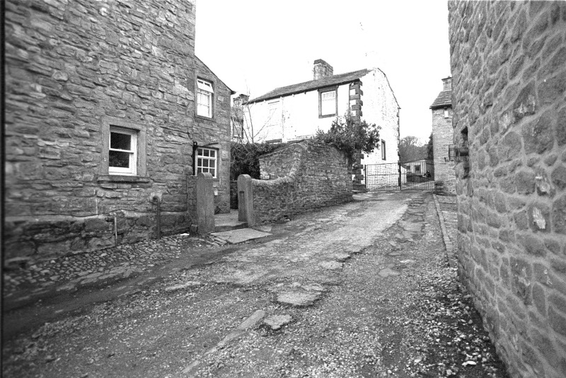
Monk's Cottages. Not an easy place to find on the google maps. They are blocked in behind other buildings.
This may help a little.
.
Monk's Cottages.jpg
Re: FORGOTTEN CORNERS
Posted: 03 Jun 2020, 17:29
by Big Kev
20200603_182707.jpg
Certainly not the easiest to see on Streetview. This is the best I could get. You can just see a bit of them between the Manchester Road houses.
Re: FORGOTTEN CORNERS
Posted: 03 Jun 2020, 18:22
by Sue
Big Kev wrote: ↑03 Jun 2020, 17:29
20200603_182707.jpg
Certainly not the easiest to see on Streetview. This is the best I could get. You can just see a bit of them between the Manchester Road houses.
Brilliant thanks
Re: FORGOTTEN CORNERS
Posted: 04 Jun 2020, 02:45
by Stanley
And that used to be the entrance to the original Clough Mill. If I remember right the far house on the left had a bell on the gable.
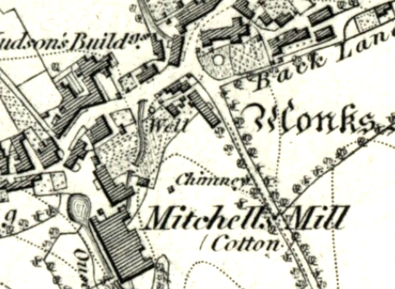
Clough Mill in 1853. I think the house that had the bell on the end was the gatehouse/manager's house.
Re: FORGOTTEN CORNERS
Posted: 05 Jun 2020, 03:57
by Stanley
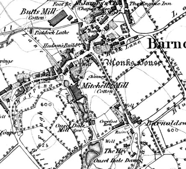
Re the last post on Clough. It was of course still known as Mitchell's Mill at the time of the survey for the first edition OS map.
More on Clough, George Shackleton's comments:
"In 1878/9 a new shed was built and a new engine installed in addition to a beam engine which I believe was the one from 1845. The new engine was a HSC slide valve engine made by Furneval of Haslingden 36" x 66". A rare bird! The engine had a tailrod VAP. I have two separate accounts that the engine was removed in 1900 and taken to Judge Walmsley Mill, near Whalley. Various people saw and photographed this engine at Whalley and at Whalley it had become a HTC by the addition of a Corliss HP cylinder, by Ashton Frost. I cannot say if the compounding took place at Barlick or Whalley but maybe the latter where there were more looms than at Clough. I suppose the debate is whether the old beam and the HSC shared the 600 looms loading or not and if not did the 36" x 66" HSC manage them. At Whalley there were 900 looms. The engine was rated 300ihp , 18" + 36" x 66", 47 rpm, 16' FW with 14 ropes whilst at Whalley.
There is an interesting bit in the Cotton Factory Times October 1891 which infers that the Furneval did the work on its own. It reads that due to looms having been removed from Clough Mill to other mills in the district, the Directors decided to re-commission the old engine (probably the 1845 beam engine) and shut down the newer engine. The old engine failed to run properly due to being 'too tight' and they recoupled the newer engine.
The question is that if the reports of the engine being removed in 1900 are correct, what powered the mill up to 1913 when the BIW's engine was put in ? The BIW's engine was O/N 108 in 1913, and 12 1/2 + 24" x 36" 8 ropes, Corliss both, with tailrod HAP as built."
Later research made it almost certain that the old beam engine was recommissioned and together with the water wheel drove the mill until 1913 when improving trade made it possible to install the new Burnley Ironworks engine which ran the mill until it stopped.
George Hogarth and the new engine. Newton's favourite. He always called it 'ticky Tock' and said it ran like a watch. It was geared for 98rpm which was a high speed for the time. Newton met the engine again after it was modified at Clitheroe and said it was a big numb wastrel and he wasn't surprised that Clough had sold it in 1900.
Re: FORGOTTEN CORNERS
Posted: 06 Jun 2020, 04:11
by Stanley
The old maps are so rewarding. Looking at this 1853 image again I was reminded of the way things change. Look at the track of the water from the mill and how it dives under Walmsgate through a culvert, what was called Town Bridge. The raising of the level of Walmsgate and the culvert were paid for by the sale of the Village Green three years before. Up to then it was on the surface and there was a ford. Note also that the Methodist chapel and Sunday school had yet to be built. At this point the tail water goes through what was to be the site of the chapel.
This anonymous gap an the left of the chapel is where the culvert comes through today, that's why it is not built on. The course of the culvert must have been modified to allow the chapel to be built and must incorporate a fairly sharp bend as well as being fully culverted right back to the mill.
I wonder how many people realise that this is why there is a bit of untidy 'unused' land next to the chapel? A forgotten corner.
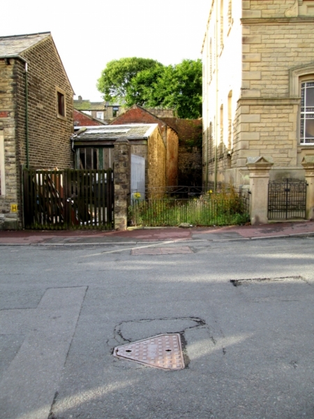
Re: FORGOTTEN CORNERS
Posted: 06 Jun 2020, 18:53
by Whyperion
That picture belongs in Pothole Corner. Lancashire CC appear to have an odd way of doing repairs , the roads are breaking up around joints and around access chamber covers. Modern chambers have a larger concrete sections with the top one extending its flat surface beyond the shape of the chamber lid, this should give a better 'key' to final road surface over the top and around the cover. A mix of ill-prepared substrate of the road and consistent heavy vehicles compacting weaker parts of the road surface , water ingress through the opening gap and freezing of the water quickly start to erode the surface leading to pot-hole potential.
Speaking of fords, traveling out the back way towards Colne up Manchester Road and then past the reservoirs ( do I end up in Higherford ) during one of the heavy rains of recent years past it was not quite certain if I would get through the ford their in a small , low , car. Its not easy to back up or reverse if you decide you cannot go on, the 'Flood' signs cannot be relied on to tell the truth as the amount of water can subside quite quickly.
Re: FORGOTTEN CORNERS
Posted: 07 Jun 2020, 04:21
by Stanley
Clough and Ouzledale water resource 1853. As you may have noticed I never stop refining my posts on water resources. As time passes I get a clearer picture. This is particularly true of Clough, Butts and Ouzledale and their relationship with Gillians Beck. If you look at the NW corner of what was in 1853 Mitchell's Mill you'll see a round pond. My understanding currently is that this is where the tail race from the water wheel exited, putting the wheel in that corner of the mill. You can see in this map that the head race ran down the West side of the mill. There was also an overflow for the lodge to the South of the mill but this isn't very clear on this image. This still exists and is the culvert that passes directly under the weaving shed and is in effect Gillians Beck.
Two things have lately become clearer. The first thing is that there was a feed from this tail race pond, most likely via a CI pipe to a balance pond in the Parrock (Paddock Laithe land) from whence it was at a high enough level to augment the flow in Calf Hall Beck which supplied the condensing water for the engines at Bracewell's new Butts Mill. This wouldn't be in place at the time this map was surveyed, it was a later date.
This suggests that the tail water was at a higher level than the culvert under the mill so there must have been another underground culvert to drain the tail water into the overflow culvert and this almost certainly had a fairly sharp fall on it as we know that Gillians Beck was at a lower level than Calf Hall Beck at the confluence of both becks below what used to be the Pigeon Club.
Not an earth-shattering piece of information but it gives a clearer picture of exactly how the resource was being managed by the Mitchell's. The importance to me is that unless we have a clear picture of the resources that enabled the mills to function we can't really fully understand them. Not only a forgotten corner but an esoteric one as well!
Re: FORGOTTEN CORNERS
Posted: 08 Jun 2020, 03:24
by Stanley
Here's a treat for you. Going back to the liquor pipe from the Gas Works.... I found this old valve cover in Back Co-operative Street a couple of days ago. It looks like the same vintage as the one in Lower North Avenue and is directly behind the section of wall with the black stain on it in the Pioneer Car Park. (Which is still very evident, I looked yesterday)
Not definite evidence but if you strike a line through the two valve covers it is heading for the gas works site and is in the centre of the road line. The theory is looking good!
Re: FORGOTTEN CORNERS
Posted: 08 Jun 2020, 13:48
by Whyperion
Ley Lines
Re: FORGOTTEN CORNERS
Posted: 09 Jun 2020, 03:46
by Stanley
Have a look at
THIS, Daniel Meadows picture story about Cyril Richardson killing a pig at Little Stainton.
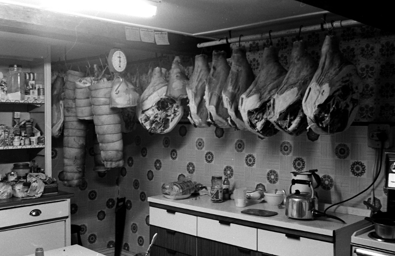
Bacon at Little Stainton in 1977. This is today's forgotten corner, proper bacon as opposed to the pickled pork that is sold as bacon today. If you put this bacon on a supermarket shelf hardly anyone would buy it, too fatty and strong. An indication of how the food processors have modified public taste in the search for profit.
The pigs that were home-killed in those days were up to 30 score weight, that's 600lbs. more than a quarter of a ton! Believe me, the taste was entirely different and when you fried the bacon there was no white chemical froth, just lovely clear fat. Once tasted, never forgotten and today's modern shoppers don't know what they are missing.
Re: FORGOTTEN CORNERS
Posted: 09 Jun 2020, 08:35
by Whyperion
BBC2 is re-running back in time for the weekend starting in 1950. given the semi-detached house (1930s or a post war build?) they chose i thought the interior was maybe over-austere was all heating coal or was clean electric the better thing? My furniture probably came from the 1950s need to re-stock - hitler had formed matchsticks of mums old bedroom furniture though my single bed remains a CC utility frame one (I need a mattress that actually works with a sprung base ) and the dark wood bedroom suite went in 1963 in favour of a remploy set in a light finish but mum's (?Co-op) one remains finished internally in a white painted finish so easy to see your shirts in a dark morning). i cannot remember mums original sofa and i dont think we have photos, I have kept a 1930s best room armchair with light oak arms that is too big really for flats, and both my nan and her sister had similar styled three piece lounge furniture, (the sofa being a two seater), dating from the 1930s , nans was finished in an embossed vinyl covering, which was interesting. I suppose my aunt must have renewed into late 50s items when she moved into her new flat (they had been living with uncles grandmother), mums flat was not built until the 1960s by which time sundays for me was a lot of church (independent mission hall) and going to the cemetary to lay flowers for grandad and feed the nearby to it horses apples, travelling in dads sidecar while he and mum were on the motorbike. Dad learned the motorbike I think in National Service. Our technology was nearly modern , in London with TVs since I am not sure when though most were second hand, decent gas stoves, hi-fi units (record player) and so on. The wife's friend in Burnley her husband moved back in the 1990s to his Mothers house - probably bulit in the 1890s and is a massive three storey terrace with Edwardian furnishings and paneling just about throughout. Functional and still with the coal fires , so life is portable electric heaters.
Re: FORGOTTEN CORNERS
Posted: 09 Jun 2020, 11:39
by plaques
Whyperion wrote: ↑09 Jun 2020, 08:35
The wife's friend in Burnley her husband moved back in the 1990s to his Mothers house - probably bulit in the 1890s and is a massive three storey terrace with Edwardian furnishings and paneling just about throughout. Functional and still with the coal fires , so life is portable electric heaters.
As a native of Burnley and having spent many a miserable hour wandering its streets I don't think there's many three story terraced houses left. Generally they were quality houses in their time but often limited on outside space. If you can remember a bit more detail can you tell me where this house was and I'll see if its in my 'Plaques' data base.
Re: FORGOTTEN CORNERS
Posted: 10 Jun 2020, 03:49
by Stanley
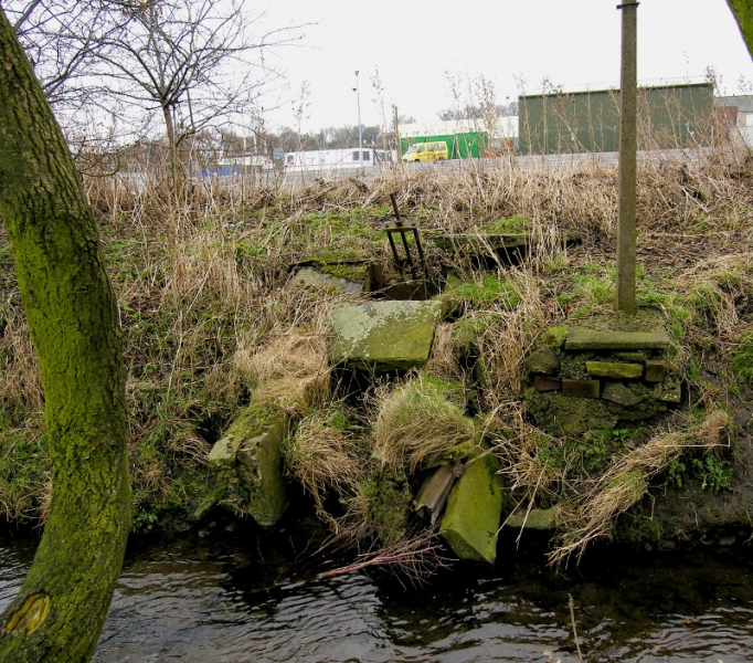
I wonder how many people walking on the side of Stock Beck in Victory Park notice this bit of old iron poking out of the rubble on the opposite bank with the present Rolls car park behind? It's the remains of the by-wash clow that used to serve the mill lodge for Old Coates Mill. The lodge was where the car park is now. The clow was used to empty the lodge if any maintenance was needed.
Another thing I discovered but which isn't visible. There is a manhole in the car park which gives access to the downstream end of the Bowker drain. (I have the plans to prove it) This drain used to be the main feed for the lodge until Bracewell cut into it at Wellhouse and took the water. I don't know what the flow is now but fifty years ago it was sufficient for Rolls to go to the expense of installing a pump and using the water for non-potable supply in Bankfield Mill. This was whey they paid Briggs and Duxbury to re-pipe a lot of the drain with 9" concrete pipes. This is why the plans were made.
How did I get the plans? I mentioned the Bowker Drain in my WEA lectures many years ago and one evening a roll of blueprints was posted through my open window on King Street. I looked out but whoever had delivered the drawings was gone. They are a complete copy of the course of the drain and I think B&D surveyed it as part of the renewal contract. Exciting stuff and a glimpse into a subject which nobody talks about. A forgotten corner.
Re: FORGOTTEN CORNERS
Posted: 11 Jun 2020, 03:28
by Stanley
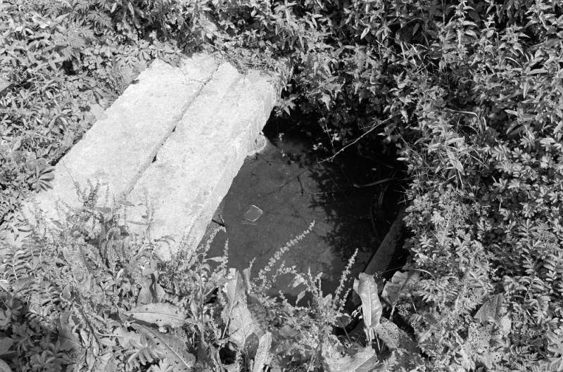
The sump in Eastwood bottoms from where Wellhouse drew its water. I did this pic in 1982, it has since been buried by landscaping the Bottoms.
Mention of the Bowker Drain yesterday triggers off the story again. I wrote this in 2016...
209 THE BOWKER DRAIN
"Yes, it's one of my Golden Oldies cropping up again. As many of you will know, the Bowker Drain has fascinated me for years, it starts near Kelbrook New Road in the meadow on the north side of the canal and follows the line of the canal to Barnsey where it goes under Long Ing Shed and the foundry, along Eastwood Bottoms, under Crow Nest cottages, through the car park for Bankfield Shed and discharges into the Stock Beck on the east side of the footbridge into Victory Park. It's flow has varied over the years because of changes upstream like the canal being made less prone to leaks and the water being drawn off it at various points but it is still a major watercourse even today.
What's brought it up again is the Boxing Day floods which at long last has triggered renewed enquiry into water flows in the town and how they can best be managed to protect us from flood damage. David Whipp is very active in these matters and as he knew of my interest in these esoteric matters he's been absorbing anything I can tell him and passing it on to the decision makers. Who says that historical research is superfluous to requirements in these modern times!
The thing that has intrigued me over the years is that despite its obvious importance, for instance it was water drawn off the Bowker Drain in Eastwood Bottoms that supplied Wellhouse Mill with all that it needed for over 100 years, every time I started asking questions about it people clammed up. Harold Duxbury knew a lot about it but when I taxed him he would just lay his finger alongside his nose and smile at me. When I was doing my Local History class one of the older members told me that he remembered walking along the side of the canal with his grandfather when he was a lad and had a flagstone in the field pointed out to him with the injunction “If ever you want some water for nowt, take it out of that drain!” and he'd always wondered what it was all about. Water is an embarrassment now but 200 years ago it was a valuable resource for driving water wheels and supplying steam engines with the coolant for the economisers on the engines that were essential for economical running. That's why ownership of riparian rights on water courses was so important and was the reason why it was a topic of interest to so many people.
With the decline of the necessity for water for manufacturing these matters started to fade into distant memory but now, because of different pressures, they are becoming important again. That's why I have been banging on about water this year and have little doubt I shall be returning to it. So, when you open your paper and realise that Stanley is on about water again, recognise that the wider any knowledge I have is spread, the less chance there might be of you getting flooded out!"
In that article I never mentioned the skulduggery that crops up when you look at the Drain. I'll have a definitive crack at that tomorrow.
Re: FORGOTTEN CORNERS
Posted: 11 Jun 2020, 09:09
by PanBiker
It supplemented the rainwater tubs in my dads allotment. I remember as a kid constant trips to the stream with a bucket. Dads patch was one allotment back from the source. Its under houses on Scothern Close now. I often think of it when I am leafleting that area.
Re: FORGOTTEN CORNERS
Posted: 12 Jun 2020, 03:50
by Stanley
The skulduggery....
Here's something I wrote a long time ago:
"William ‘Billycock’ Bracewell took a bold leap when he built Butts Mill on a restricted site in 1846/48 and undoubtedly learned a lot. In 1854/55 he built another mill, at first called New Mill but very soon known as Wellhouse. This was also a combined spinning and weaving operation. The spinning was in the main three storey building which also contained the boilers and engines, the weaving was in a single storey weaving shed adjoining. Walt Fisher once told me that the original Victoria Mill in Earby (1856) was almost a carbon copy of Wellhouse.
The most surprising thing about Wellhouse is that it was possibly the worst site in Barlick for a mill. It was on bottom land with a high water table, very silty and soft and not the ground one would choose for strong foundations, remember the problem Johnny Pickles had with the footings for the Havre Park foundry next door to Wellhouse? It was a brave man that built a sixty yard chimney on such ground apart from the rest of the buildings. There was another circumstance that puzzled people who knew about these things, there was no obvious supply of the water on the site to feed the condenser pond which made the engine efficient.
This isn’t the place to delve into all the history of water provision on the site but all my research points to the fact that Billycock had been preparing for this build by gaining control of the Butts Beck at the Corn Mill after 1850 and building a large land drain from Salterforth called the Bowker Drain at the same time. These strategies fitted in with his overall plan which seems to have been to disrupt his cousin’s water supply at Old Coates Mill. His aim was dominance and family connections weren’t going to be allowed to get in the way. The water supply was always a problem but by the time he started the mill he had sufficient to work the engines economically."
Just one thing about that, I am not really sure that Bracewell put the Bowker Drain in. It could be much earlier when William Bracewell of Coates built the original Coates Mill. Also I have no idea why it is called the Bowker Drain. Is this the surname of the man who built it or does it refer to an area called Bowker Ing in Barlick, a name I have stumbled on but have no idea where it is. One complicating factor is that I have evidence that when the canal was built at the end of the 18th century, two wooden culvert pipes were installed to drain the water from the North side of the canal into a drain on the south side and this can only have been done as the canal was being put in. This coincides with the Building of the original Coates Mill.
What I am sure about is Billycock Bracewell's intent to deprive his cousins of the benefit of the water as he installed a 6" CI pip;e to convey the overflow from the dams at Wellhouse direct to Stock Beck at a level too low for the cousins to use it. Harold Duxbury proved this by colouring the overflow when he as managing director of the Calf Hall Shed Company and in charge of the water at Wellhouse as the CHSC owned the mill.
It's no coincidence that Old Coates failed and the cousins were bankrupted at the same time that Billycock was taking these steps. True there were other factors like bad trade but it's too much of a coincidence. This theory is reinforced by the fact that when Nuttall bought the old mill and attempted to restart it in the 1850s, Billycock took him to Chancery Court to block any use of the overflow water which was in affect almost the total flow of the Bowker Drain.
I could go on but I think you might have a clue now as to why this fascinates me. Every time I posed questions about the drain I hit a brick wall. Even Harold knew things he wouldn't reveal. When I directly questioned him about it he just laid his finger on the side of his nose and smiled at me...
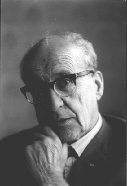
Harold.
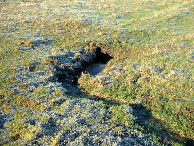
Here's the feeder for the Bowker drain diving under the canal in the meadow opposite Lower Park Marina.
Re: FORGOTTEN CORNERS
Posted: 13 Jun 2020, 03:31
by Stanley
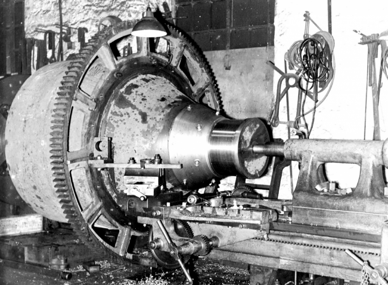
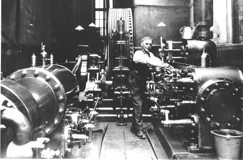
Yes, another boring engineering pic! But hold on a bit and hear the story. During WW1 Brown and Pickles had an opportunity for more work if they could machine parts that were too big for any normal lathe. Johnny set to and designed and made this 'Break Lathe' which was unusual in that it relied on a large casting embedded on the floor as the bed. They could machine parts over seven feet in diameter and it was a good investment over the years. Here it is machining a large part in peace time. It was particularly useful for truing the tyres on large locomotive driving wheels, I have seen Newton doing them in my time using this lathe. It was installed in the old laundry at Wellhouse and when the shop was demolished and the business bought by Gissing's it was scrapped.
The point about it is that Johnny was faced with the problem of getting a large lathe when none were available from the machine manufacturers so he designed and built his own using resources available in the town like Ouzledale Foundry for the castings. It was completely successful and fit for purpose. Such a course would be unthinkable today so it qualifies as a forgotten corner.
Re: FORGOTTEN CORNERS
Posted: 14 Jun 2020, 04:09
by Stanley
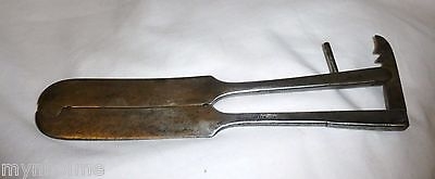
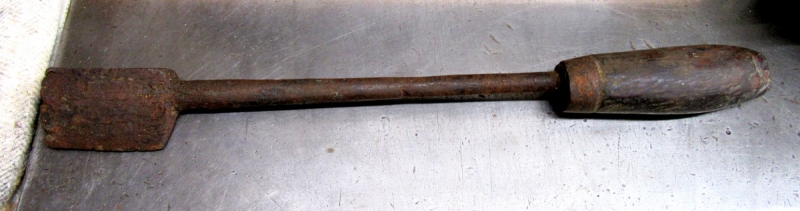
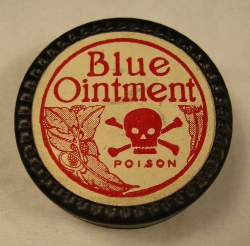
Not many people have had experience of using these tools, luckily I am not one of them and whilst unpleasant to some the knowledge is worth preserving.
They are both tools used to castrate larger beasts lie stirks or young horses. The clamp was attached and tightened above the scrotum and the iron, heated red hot, was used to cut it off below the clamp, that action also cauterised the wound which was then liberally coated with 'Blue Salve' which I believe was ammoniated mercury based ointment.
This all sounds incredibly cruel but it was effective, quick and didn't cause the animal excessive distress. A good guide to how traumatic it was is that when you undid the ropes used to restrain the beast and offered them food and water they started eating and drinking immediately and if turned out they just started quietly grazing and walked normally. In the cases that I was concerned with there was no secondary infection and it was effective.
I know there will be an outcry from some but when it was superseded by using rubber rings as in lambs they used to evince signs of acute discomfort in that they walked very badly and frequently their back legs gave way and you could detect this for up to 36 hours afterwards. This never happened with hot iron cauterisation.
So there you are, a bit of history and a forgotten corner, we have better methods now but remember this was a very ancient practice and was definitely the best treatment available.
Re: FORGOTTEN CORNERS
Posted: 15 Jun 2020, 03:42
by Stanley
The southern end of the Black Dyke above Blacko. The Black Dyke is still a very visible feature on the boundary between Whitemoor and Admergill even though it must have been gradually filling ever since it was dug. It is an obvious boundary ditch and I can only assume, because of its age was a tribal boundary long before the advent of later boundaries. It was described as 'ancient' on the Whitemoor Map of 1580 and was ignored by William de Lacey in his perambulation of what he thought was the boundary between the Forest of Blackburnshire when preparing to gift the Manor of Barnoldswick to the priors of Fountains Abbey in the 12th century. By 1580, after interminable court cases and judgements it was regarded as the western boundary of the Manor.
What has always surprised me is the almost complete absence of any mention of it in the history I have read of the area. It is such an obviously important feature of the landscape. If you want a glimpse of it without walking it is clearly visible off Old Gisburn Track from the rise before Sandiford. Definitely a forgotten, if not ignored, corner.
Re: FORGOTTEN CORNERS
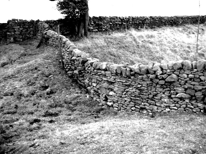
Posted: 16 Jun 2020, 03:44
by Stanley
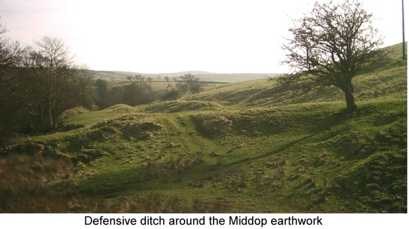
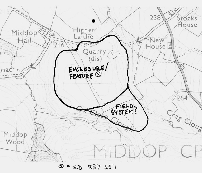
John Clayton's pic of the massive earthworks at 'Middop Camp'. I use the apostrophes because we still aren't absolutely sure what it is. My favourite is an Iron Age settlement with defensive ditches that subsisted on the trade along the old track over Middop from Ireland to the Baltic via Kildwick. It is enormous and I remember when I first saw it I couldn't believe what I was looking at. The work that went into the ditches and defensive features is mind-boggling. I consulted with the County Archaeologist and he agreed with me but said to keep quiet as he didn't want night hawks going up there with metal detectors. It needs a major archaeological investigation but who will fund it?
You can still identify the features, a grave yard, a cultivated area outside the camp and entrances cunningly designed to be easily defended in case of attack. Very little mention of it in the record. A largely unknown corner.