EARLY SETTLEMENT IN WEST CRAVEN
-
Stanley

- Global Moderator

- Posts: 90439
- Joined: 23 Jan 2012, 12:01
- Location: Barnoldswick. Nearer to Heaven than Gloria.
Re: EARLY SETTLEMENT IN WEST CRAVEN
That map is the first edition OS 6" published 1853. The 'well' marked in Hey Farm field used to be the water supply for the house and is drained down to the beck in a stone drain. There was another big drain about half way across the field from there to the boundary with Bancrofts land. That land is owned by the Demaines and they live in the bungalow opposite the Bancroft engine house. If you call in there and tell them I put you onto them I think you'll be welcome. The sun shines out of my bottom there as I gave Young Sid Demaine the right of way through Hey Farm yard which ensured there would be no problems of access when they applied for permission to build the bungalow following my sale to them of the field which gave them enough acreage to automatically get planning permission as an agricultural holding. I sold it for £3000, a lot of money in those days!
Stanley Challenger Graham
Stanley's View
scg1936 at talktalk.net
"Beware of certitude" (Jimmy Reid)
The floggings will continue until morale improves!
Stanley's View
scg1936 at talktalk.net
"Beware of certitude" (Jimmy Reid)
The floggings will continue until morale improves!
-
David Whipp
- Senior Member
- Posts: 2874
- Joined: 19 Oct 2012, 18:26
Re: EARLY SETTLEMENT IN WEST CRAVEN
Memory tells me that the land to the east of Letcliffe Park used to be owned by Fred Birtwistle and is likely to remain within the family's ownership. Will make some enquiries.
-
Whyperion

- Senior Member
- Posts: 3073
- Joined: 23 Jan 2012, 22:13
- Location: Stockport, after some time in Burnley , After leaving Barnoldswick , except when I am in London
Re: EARLY SETTLEMENT IN WEST CRAVEN
Some of the larger terrace houses on Manchester Road backing onto the back ginnel parrallel to Cobden Street have Cellars (to my knowledge ours didn't though the front retaining wall must have held back a large amount of soil) , might be worth asking around and poking around a bit if you are searching for old stuff. Would there be any old stones (or timbers) re-used internally within the likes of The Greyhound ?
-
John C Layton
- Newbie
- Posts: 54
- Joined: 09 Dec 2015, 15:57
Re: EARLY SETTLEMENT IN WEST CRAVEN
Whyperion - it would be a good idea to look in the retaining walls etc. in the terraced banking behing Manchester Rd - there would be no timbers but possible reused early stonework.
Stanley - you put an image in the Forgotten Corners forum - Hill Top Farm - ignoring the building this is a great photo as it shows what I am fairly sure was part of the defensive system relating to Letcliffe.
Barlick Roman fort update - I have been casting the net further afield (north of Stock Beck) and the possibility of a Roman site at Barlick grows by the day. After much research on the Roman town and associated agricultural system I have formulated a theory. This is now being proved on the ground through LiDAR - this involves mapping in GIS every field wall, stream, ditch and hollow for every farmstead that shows signs of early settlement. This is proving to be a mammoth task as the area Kelbrook to Long Preston is littered with very early agricultural systems. Every time I finish one site (2-3 days of a job) another pops up in the neighbourhood.
I am confident that we are rewriting our local and national history here and that West Craven was a very important part of both the British kingdom and Roman military systems. Because the Barlick site has been competely destroyed it is difficult to say whether it was a fort, small Roman town or agriculture operation. However, in the last few days two Roman forts have come to light a mile or two north of Barlick. These are in green fields, with associated lost villages/towns and can therefore be better assessed. The Barlick site compares closely with these new finds and this edges the site towards a 'fort.' We now have at least three of these sites within our district around Barlick and I think that we are looking at a class of enclosure not recognised before. Not strictly military (the Elslack fort was for this purpose) but closely allied to the military with a main purpose of controlling the agricultural output of the native British farmers. It appears at this stage of the research that the area was more intensively farmed than it has ever been since and there were more farm units in that period.
To make any sense of the Barlick site fieldwork is needed and this requires persmissions for looking over the Letcliffe land I highlighted in an earlier post - also Brogden Hall Farm and Hey Farm lands. I don't have time to organise field outings but would be more than happy to come along if anyone can manage to organise them.
-
Stanley
- Global Moderator
- Posts: 90439
- Joined: 23 Jan 2012, 12:01
- Location: Barnoldswick. Nearer to Heaven than Gloria.
Re: EARLY SETTLEMENT IN WEST CRAVEN
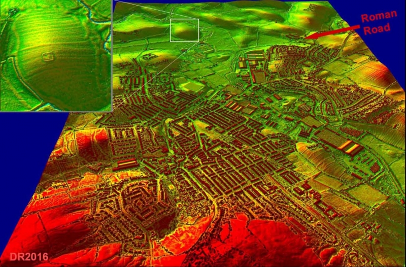
Chris Aspin forwarded this image to me yesterday, click to enlarge. He had mentioned our work to a bloke called David Ratledge who sent Chris this image and basically rubbished the idea there could be anything detected by LIDAR in a built up area. I told Chris that I wasn't impressed by anyone who casts aspersions on other people's work if they haven't looked at the evidence. Evidently he's an 'expert' on Roman Roads.... According to his version the feature on the North side of the town is the important bit.....
Back to our hypothesis. I'm sure there are clues in the ancient bank to the East of the track up to Letcliffe. I have always said two things about the general history of the town, and they hold true for anywhere you care to look. First, the more we look, the more we find. Second, beware the 'historical fact', research changes perspectives as we learn more. For many years the 'authorised version' was that Greenberfield Lane etc was part of the Roman road from Ilkley to Ribchester and it avoided Barlick. End of! However, when I wrote my potted history of Barlick I voiced my doubts about this view because I couldn't imagine the Romans, who were always on the look out for resources (That was the reason they first came to the Isles in 44BC, they needed grain to support the armies in Gaul), would have ignored an area like West Craven because the evidence I was uncovering proved that the area was very productive.
It's worth mentioning here two pieces of evidence. There was the record of purchases of grain and timber from Barlick in the Bolton Priory Compotus and the Whitemoor Map shows that there were 16th century enclosures on the waste in Foulridge, Salterforth and Barlick which denotes pressure on agricultural land caused by population growth. No point going to the trouble of enlarging agricultural land unless there was a local demand. Two factors are fundamental to to this version, the 16th century growth couldn't have been a factor in the Roman era, it was the growth of woollen textiles which meant that people could gain independence and marry earlier when they were more fertile and hence trigger population growth. The second applied in the Roman era and was a factor in the first, the micro climate generated by the protection of the lands to the East of Whitemoor from the prevailing SW weather patterns. I believe this was why we could grow big trees and grain.
I like the idea of whatever there was on the Cobden Street being a Roman army service corps supply depot, trading with the locals and feeding resources of food and timber into the main body of occupying troops. Remember that we were not part of the Britannic Civitas, we were a border region under military control. I've always said that the best way to view such an occupation force was to think of it as an armed body of civil engineers who always exploited local resources. They used enormous quantities of food and timber.
We should also bear in mind that the Roman Influence could have had other effects. Here's something I wrote recently....
"It may be that some light is shed on another of my Barlick puzzles. When Serlo the monk was giving his evidence about the founding of the monastery in Barlick in the 12th century he said that there was already an 'ancient church' later demolished by the Cistercians. How old is 'ancient'? Nicene Christianity became the state church of the Roman Empire with the Edict of Thessalonica in 380 CE, when Emperor Theodosius I made it the empire's sole authorised religion. Could it be that the presence of the Romans was the catalyst that brought Christianity to Barlick?"
The more we plug away at this the clearer the picture will become. Already we have (in my opinion) enough evidence to spur us on to dig deeper. And I haven't forgotten my Saxon church!
Stanley Challenger Graham
Stanley's View
scg1936 at talktalk.net
"Beware of certitude" (Jimmy Reid)
The floggings will continue until morale improves!
Stanley's View
scg1936 at talktalk.net
"Beware of certitude" (Jimmy Reid)
The floggings will continue until morale improves!
-
PanBiker

- Site Administrator

- Posts: 16488
- Joined: 23 Jan 2012, 13:07
- Location: Barnoldswick - In the West Riding of Yorkshire, always was, always will be.
Re: EARLY SETTLEMENT IN WEST CRAVEN
If I have my bearings right, the feature of importance according to Mr Ratledge is the earthworks on Gilbeber Hill towards Stock, already excavated in the past. Does he expand on why this is the only thing of note on the image?
Ian
-
John C Layton
- Newbie
- Posts: 54
- Joined: 09 Dec 2015, 15:57
Re: EARLY SETTLEMENT IN WEST CRAVEN
Spot on Stanley. As for David Ratledge - he's wrong an a number of counts. It is one thing 'finding ' lost Roman roads on LiDAR (that stick out like a sore thumb) and quite another locating and interpreting subtle features within the ancient landscape. The LiDAR he sent is a stitched supra-metre image and is useless for any serious work. Further, the proposed Roman enclosure below Letcliffe was not found using LiDAR, I spotted it as a ditched enclosure on the early OS map. The square enclosure on Gilbeber, to the north, is not the most important site in the area and anyone who thinks this is the case needs to spend a few years surveying in West Craven.
-
Wendyf

- Global Moderator
- Posts: 9459
- Joined: 23 Jan 2012, 12:26
- Location: Lower Burnt Hill, looking out over Barlick
Re: EARLY SETTLEMENT IN WEST CRAVEN
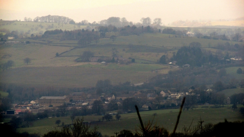
My view of Letcliffe is a bit distant but very clear at the moment especially with a low sun picking out details of the landscape. I now have a superimposed image fixed in my head...like they used to do on Time Team.... of a cluster of round houses sat up there with trails of smoke coming from them. 
-
John C Layton
- Newbie
- Posts: 54
- Joined: 09 Dec 2015, 15:57
Re: EARLY SETTLEMENT IN WEST CRAVEN
Any chance of a photo Wendy?
-
Wendyf
- Global Moderator
- Posts: 9459
- Joined: 23 Jan 2012, 12:26
- Location: Lower Burnt Hill, looking out over Barlick
Re: EARLY SETTLEMENT IN WEST CRAVEN
Yes, I'm watching out for the right moment, it's a bit hazy today.
-
Wendyf
- Global Moderator
- Posts: 9459
- Joined: 23 Jan 2012, 12:26
- Location: Lower Burnt Hill, looking out over Barlick
Re: EARLY SETTLEMENT IN WEST CRAVEN
I've slightly enhanced a very hazy picture. I'll try again on a brighter day.
-
Stanley
- Global Moderator
- Posts: 90439
- Joined: 23 Jan 2012, 12:01
- Location: Barnoldswick. Nearer to Heaven than Gloria.
Re: EARLY SETTLEMENT IN WEST CRAVEN
Ian. ignore Ratledge. I get the impression that if he hasn't found it it can't be important.
Stanley Challenger Graham
Stanley's View
scg1936 at talktalk.net
"Beware of certitude" (Jimmy Reid)
The floggings will continue until morale improves!
Stanley's View
scg1936 at talktalk.net
"Beware of certitude" (Jimmy Reid)
The floggings will continue until morale improves!
-
John C Layton
- Newbie
- Posts: 54
- Joined: 09 Dec 2015, 15:57
Re: EARLY SETTLEMENT IN WEST CRAVEN
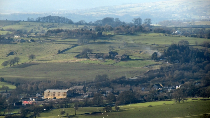
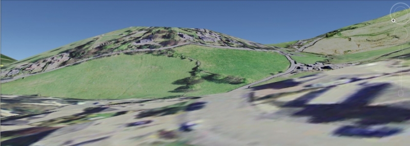
Thanks for the image Wendy - I've never looked at Letcliffe from this direction - goes some way to confirming what I hoped would be on that side of the site.
Have drawn in two features that stand out - the lighter one appears to be a well defined right-angle bank and ditch and the orange line is the probable outer defensive terrace running down into town. These are classic defences and would have protected any settlement on the hill top (the car parks and swings of the park).

Have drawn in two features that stand out - the lighter one appears to be a well defined right-angle bank and ditch and the orange line is the probable outer defensive terrace running down into town. These are classic defences and would have protected any settlement on the hill top (the car parks and swings of the park).
-
Wendyf
- Global Moderator
- Posts: 9459
- Joined: 23 Jan 2012, 12:26
- Location: Lower Burnt Hill, looking out over Barlick
Re: EARLY SETTLEMENT IN WEST CRAVEN
I think your orange line shows the course of Hodge Lane. It's a brighter day, so I might be able to get a better pic.
-
Wendyf
- Global Moderator
- Posts: 9459
- Joined: 23 Jan 2012, 12:26
- Location: Lower Burnt Hill, looking out over Barlick
Re: EARLY SETTLEMENT IN WEST CRAVEN
A clearer photo from this afternoon.
-
Stanley
- Global Moderator
- Posts: 90439
- Joined: 23 Jan 2012, 12:01
- Location: Barnoldswick. Nearer to Heaven than Gloria.
Re: EARLY SETTLEMENT IN WEST CRAVEN
Good image Wendy, I have stolen it for the archive! You are right, that orange line is the course of Hodge Lane, very old route, clearly shown on the 1580 map of Whitemoor made for the court case between Foulridge and Barlick.
Stanley Challenger Graham
Stanley's View
scg1936 at talktalk.net
"Beware of certitude" (Jimmy Reid)
The floggings will continue until morale improves!
Stanley's View
scg1936 at talktalk.net
"Beware of certitude" (Jimmy Reid)
The floggings will continue until morale improves!
-
John C Layton
- Newbie
- Posts: 54
- Joined: 09 Dec 2015, 15:57
Re: EARLY SETTLEMENT IN WEST CRAVEN
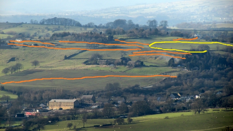
Nice one Wendy - have highlighted possible defensive ditches and banks.
An exaggerated view looking east across Letcliffe shows the level area on the hill top.
-
Stanley
- Global Moderator
- Posts: 90439
- Joined: 23 Jan 2012, 12:01
- Location: Barnoldswick. Nearer to Heaven than Gloria.
Re: EARLY SETTLEMENT IN WEST CRAVEN
The thing that always struck me on Letcliffe is the fields of view, particularly to the North. That's why the view point table is there. One thing I learned when researching the de Lacey perambulation of the boundary of the Manor of Barnoldswick was that any height like 'Alainset - Alan's Seat, was a view point used to delineate boundaries before the days of formal cartography. Letcliffe would be ideal and incidentally one of the eminences marked on the view point is Percy's Seat beyond Skipton.... It reminds me of the survivalist red neck I had a conversation with in the States who told me that the first consideration when buying a property should be fields of fire.
Stanley Challenger Graham
Stanley's View
scg1936 at talktalk.net
"Beware of certitude" (Jimmy Reid)
The floggings will continue until morale improves!
Stanley's View
scg1936 at talktalk.net
"Beware of certitude" (Jimmy Reid)
The floggings will continue until morale improves!
-
6fingerskipton
- Newbie
- Posts: 6
- Joined: 14 Feb 2016, 16:26
Re: EARLY SETTLEMENT IN WEST CRAVEN
Apologies for not initially writing a New Member post, however I've been reading through this forum with quite some vigour due to its interesting nature on local history, I'm far from a historian myself but cant help studying OS Maps and aerial photography for hours on end.
I did try loading up some LIDAR imaging but kept failing spectacularly and with there being some blank spots around my area of interest(Skipton and northwards) it didn't motivate me to keep trying. I have however stumbled across the following site on which some helpful souls have integrated most of the LIDAR images and a few Mapping overlays which may prove useful to some of you.
http://enfarchsoc.org/opendata/
If you click the Layers button, select the LIDAR mode and then fettle with the opacity you can get quite a nice blend of map and imaging. I have found it useful to find the area of interest them completely turn the LIDAR up to full. There are more layers which can enable conservation areas amongst others but I've yet to use them.
*I'm not in anyway affiliated to that site, just a simpleton from Skipton!
Cheers
C.
-
jpmurray681
- Newbie
- Posts: 31
- Joined: 06 Nov 2014, 15:05
Re: EARLY SETTLEMENT IN WEST CRAVEN
What a fantastic addition to the history hunters armoury. I wonder if it'll assist my search for 2 long lost Whalley Abbey boundary points which exist in the area and which created interest last year and which I havn't given up on yet. I'd already wondered if the lidar searches of the area might unearth something relevant to my subject as well as, of course, the more important history of your area. Good hunting to all. I watch with growing interest
-
Whyperion
- Senior Member
- Posts: 3073
- Joined: 23 Jan 2012, 22:13
- Location: Stockport, after some time in Burnley , After leaving Barnoldswick , except when I am in London
Re: EARLY SETTLEMENT IN WEST CRAVEN
Question - and move to diff topic if required. Manchester Road. Is it lower than ground level to one side because it was hewn out in the more recent past, say 1580 or later, sometime after noirman invasiion, just after BCE or earlier than that? Is it natural (Glacier or watercourse erosion) or widened on flattened by many feet human or animal over the years. I know past the greyhound it was until LCC ? Yorkshire council? Widening a bit narrower, and where there older routes that were used more preferentially ?
-
Stanley
- Global Moderator
- Posts: 90439
- Joined: 23 Jan 2012, 12:01
- Location: Barnoldswick. Nearer to Heaven than Gloria.
Re: EARLY SETTLEMENT IN WEST CRAVEN
All these old routes started off as local footpaths and wear and tear deepened and widened them over thousands of years. If on a hillside this naturally leads to one side being a bank and the other a fall off to lower levels. Water running down the paths on a slope further accelerated the wear and you end up with something like Barnoldswick Lane or High Lane further on towards Blacko. These routes could quite easily date back 4,000 years or even earlier.
The paths started as a direct walking route between where you were and where you wanted to be so their was no question of alternative routes unless there was some insurmountable obstacle. In short, they weren't planned, Like Topsy, they 'just growed'.
The paths started as a direct walking route between where you were and where you wanted to be so their was no question of alternative routes unless there was some insurmountable obstacle. In short, they weren't planned, Like Topsy, they 'just growed'.
Stanley Challenger Graham
Stanley's View
scg1936 at talktalk.net
"Beware of certitude" (Jimmy Reid)
The floggings will continue until morale improves!
Stanley's View
scg1936 at talktalk.net
"Beware of certitude" (Jimmy Reid)
The floggings will continue until morale improves!

Re: EARLY SETTLEMENT IN WEST CRAVEN
Thanks 6fingers.. for the map link. I hope you realize that I spent over a hour each night playing with this thing. I can see John's point in that the finer the resolution the smaller the 'ripples' you can see. Fascinating!
-
jpmurray681
- Newbie
- Posts: 31
- Joined: 06 Nov 2014, 15:05
Re: EARLY SETTLEMENT IN WEST CRAVEN
this threads gone a little quiet but no doubt it will liven up again soon so i'll pose a question for Stanley.
Some months ago you felt that you may have detected the site of an ancient hill fort just off the Gisburn road, have any of the links enabled you to verify that idea?
Some months ago you felt that you may have detected the site of an ancient hill fort just off the Gisburn road, have any of the links enabled you to verify that idea?
-
Stanley
- Global Moderator
- Posts: 90439
- Joined: 23 Jan 2012, 12:01
- Location: Barnoldswick. Nearer to Heaven than Gloria.
Re: EARLY SETTLEMENT IN WEST CRAVEN
That's a long time ago JP. Not sure about detected, if you go up there and have a look it hits you in the face! That's all the 'verification' that's needed for its existence. As to whether it is a hill fort.... The works look defensive but it could be that it had another function like a village or a meeting place but it is so enormous that I can't help thinking there was habitation. You can identify farmed sections of the moor outside the boundaries and in one corner a possible burial site. No, I haven't looked at the LIDAR for the area. The County Archaeologist knew about it when I asked but said that it was so big they hadn't the resources to dig. This was 30 years ago and the situation will be even worse now so as long as it isn't under threat the best thing is to let it be. It isn't going to go away!
Stanley Challenger Graham
Stanley's View
scg1936 at talktalk.net
"Beware of certitude" (Jimmy Reid)
The floggings will continue until morale improves!
Stanley's View
scg1936 at talktalk.net
"Beware of certitude" (Jimmy Reid)
The floggings will continue until morale improves!