Page 25 of 316
Re: FORGOTTEN CORNERS
Posted: 01 Sep 2013, 08:53
by PanBiker
A Bronze Age axe head was found in that field by a local metal detectorist in the early 80's. It is recorded on the PAS database and is on display in the Craven Museum in Skipton. It has decoration punched into the metal, an ancient thing of purpose and beauty.
Re: FORGOTTEN CORNERS
Posted: 02 Sep 2013, 03:45
by hartley353
PanBiker wrote:This gate protects the path to the front gardens of Wellhouse Square which I think I am correct in saying pre-dates the other rows of houses built around it. The path continues along the frontage of the square as well. I think Stanley's explanation for why it is there is perfectly feasible and based on historical evidence rather than some fanciful idea of the why's and wherefores viewed from afar.
I know it well having lived on Wellhouse square, I also note its concrete footings.Our front garden faced the woodyard. The last time I passed through it was 2004.
Re: FORGOTTEN CORNERS
Posted: 02 Sep 2013, 04:25
by Stanley
Ian, do you remember the bloke who found two gold torques in Barlick who came on the old site but than vanished?

John Clayton's pic of some of the earthworks at Middop. The enclosure is huge and when I asked the County Archaeologist about it he said that I was right, it's there and needs investigating but as ever the governing factor is funding.
Re: FORGOTTEN CORNERS
Posted: 02 Sep 2013, 07:49
by hartley353
During the 50,s a pal and myself used to cast arrow heads, spear tips, and axe heads from aluminium. We collected scrap ally from any where and smelted it in an iron pot in the coke fired furnace in his dads greenhouse. This may have caused some head scratching when folks with metal detectors dug them up. Many where lost along the banks of stock beck. The methods and designs came from a book in Barlick libary.
Re: FORGOTTEN CORNERS
Posted: 03 Sep 2013, 04:46
by Stanley

The entrance to Victory Park. We forget these days that for years it was the Council Tip!
Re: FORGOTTEN CORNERS
Posted: 04 Sep 2013, 05:21
by Stanley

A foot and mouth prohibition notice on Letcliffe in March 2001.
Re: FORGOTTEN CORNERS
Posted: 05 Sep 2013, 05:18
by Stanley

The3 view over Valley Gardens to the gasworks in 1982.
Re: FORGOTTEN CORNERS
Posted: 06 Sep 2013, 06:08
by Stanley

Ken and Ern's shop on Rainhall Road in 1983.
Re: FORGOTTEN CORNERS
Posted: 07 Sep 2013, 04:17
by Stanley

The Newtown end of Rainhall Road in 1983. Remember the Pram Shop?
Re: FORGOTTEN CORNERS
Posted: 08 Sep 2013, 05:24
by Stanley

Butts Top in 1982.
Re: FORGOTTEN CORNERS
Posted: 09 Sep 2013, 05:17
by Stanley

Manchester Road just before it was widened in the mid 1960s. The man with the dog in the foreground is Garra Pickles.
Re: FORGOTTEN CORNERS
Posted: 10 Sep 2013, 05:31
by Stanley
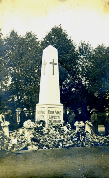
The temporary wooden cenotaph in Letcliffe Park after the Great War.
Re: FORGOTTEN CORNERS
Posted: 11 Sep 2013, 07:31
by Stanley

This very old kissing gate on Shitten Ginnel has always fascinated me. There is no obvious reason why it should be there and I can't help thinking it's a clue to something. Question is; what?
Re: FORGOTTEN CORNERS
Posted: 12 Sep 2013, 06:54
by Stanley

This could be the answer to my kissing gate. This the field to the south of the gate and as I learn more about Barlick I become more and more convinced that it is the site of the early church in Barlick. And yes, I did jump through all the hoops and put it up as a project to Time Team but never got any response.
Re: FORGOTTEN CORNERS
Posted: 13 Sep 2013, 05:36
by Stanley

Click on this for a larger image. This is part of my current puzzle and definitely a forgotten corner. St Mary's Well is probably an important Pagan site. Of course it wasn't called after St Mary then, this came in when the Cistercians arrived, they dedicated all their monasteries to the Virgin Mary (or possibly the Saxon Church was dedicated to St Mary and it was renamed in the 7th century). This is the 1892 map and the well is clearly marked. The accepted story is that it was capped when Calf Hall Lane was re-aligned and the cattle grid installed but according to Harold Duxbury, Stephen Pickles Senior once showed him a slab of stone over the wall at the end of Shitten Ginnel on the right facing Calf Hall Lane and just before the junction with the lane. Stephen was quite clear, that this was the original well. In other words diametrically opposite to where it is marked on the 1892 map. Weight has to be given to what Stephen said because he was of the generation that relied for their living on knowing where the sources a water were in the town. Things are complicated by the fact that this corner has been used over the years for spoil created by the building of the Calf Hall extensions and whatever is there is buried. If someone wants a small archaeological investigation site, this could be a goodie. (The field to the North of this map on the other side of the lane is marked as the site of the monastery.)
[One lesson to be learned from this if I am right is that even the Ordnance Survey got it wrong sometimes]
Re: FORGOTTEN CORNERS
Posted: 14 Sep 2013, 05:36
by Stanley

Church Street opposite Jepp Hill in 1984.
Re: FORGOTTEN CORNERS
Posted: 15 Sep 2013, 05:57
by Stanley

The remains of Upper Hall at the end of Lister Well Lane in 2001.
Re: FORGOTTEN CORNERS
Posted: 16 Sep 2013, 05:26
by Stanley

This is a repeat but I've posted it again because in my check of the LTP2013 on the dev site I was reminded that when what was known as 'The Brick School', built by Billycock Bracewell became redundant when York Street school was built, it was taken over by Phineas Brown who ran his light electrical engineering business from here befor moving into Hartley's redundant swimming baths on the Croft where amongst other things he had an ice-making plant. This later became Croft Garage.
Re: FORGOTTEN CORNERS
Posted: 17 Sep 2013, 05:12
by Stanley

The old Croft garage on Sagin Hill. I was told once that it was originally a billiard hall but later found that Matthew Hartley (Majestic Cinema) built it as a swimming bath but had to abandon that idea when the Council refused to lay a bigger water main to it. Phineas Brown used it for ice-making and as a base for his electrical contracting business for a while but then it became Croft Garage. I think it's used for storage now.
Re: FORGOTTEN CORNERS
Posted: 17 Sep 2013, 15:55
by elise
Stanley wrote:
This is a repeat but I've posted it again because in my check of the LTP2013 on the dev site I was reminded that when what was known as 'The Brick School', built by Billycock Bracewell became redundant when York Street school was built, it was taken over by Phineas Brown who ran his light electrical engineering business from here befor moving into Hartley's redundant swimming baths on the Croft where amongst other things he had an ice-making plant. This later became Croft Garage.
Until March 1963 this was a Rolls-Royce social club when it amalgamated with the one on Skipton Road
Re: FORGOTTEN CORNERS
Posted: 17 Sep 2013, 16:11
by elise
Stanley wrote:
The old Croft garage on Sagin Hill. I was told once that it was originally a billiard hall but later found that Matthew Hartley (Majestic Cinema) built it as a swimming bath but had to abandon that idea when the Council refused to lay a bigger water main to it. Phineas Brown used it for ice-making and as a base for his electrical contracting business for a while but then it became Croft Garage. I think it's used for storage now.
Harold Duxbury told a friend of mine it was at one time used for lantern film shows.
Re: FORGOTTEN CORNERS
Posted: 18 Sep 2013, 04:24
by Stanley
Elise, I knew that the Brick School was Ouzledale Foundry club but didn't know about RR.

The old mortuary in Butts. I was told once that this corner was originally the Pound where stray animals were put until claimed.
Re: FORGOTTEN CORNERS
Posted: 18 Sep 2013, 10:26
by elise
Stanley wrote:Elise, I knew that the Brick School was Ouzledale Foundry club but didn't know about RR.
The old mortuary in Butts. I was told once that this corner was originally the Pound where stray animals were put until claimed.
The pinfold is shown down Butts on the Barnoldswick Enclosure map
Re: FORGOTTEN CORNERS
Posted: 19 Sep 2013, 04:14
by Stanley
Never seen that map. Where is the pound shown?

I have this pic of an unknown police force in 1890. Anyone know where it is? It strikes me that this pic illustrates the point I made to Plaques in the photography thread. Even a boring pic can get interesting as the years go by. Love the single plain clothes man and the faces at the window on the left....
Re: FORGOTTEN CORNERS
Posted: 19 Sep 2013, 17:52
by plaques
Police Force Picture.
The photo is of the Nelson Police taken outside the police station on Cross St. This is now part of the Nelson town hall.
The carved heads on each side of the doorway are still present. The words "Police Offices" have been removed.