Wendy has it in a nutshell, additionally here is the link posted earlier to the site topic which you may have missed.
Images Tips and Tricks
EARLY SETTLEMENT IN WEST CRAVEN

Re: EARLY SETTLEMENT IN WEST CRAVEN
Sorry, but I'm totally lost where this map is supposed to be. Could you give some X-Y co-ordinates, so that I could cross reference them to the Lancashire Mario Maps. Thanks.
-
Wendyf

- Global Moderator

- Posts: 9496
- Joined: 23 Jan 2012, 12:26
- Location: Lower Burnt Hill, looking out over Barlick
Re: EARLY SETTLEMENT IN WEST CRAVEN
Try putting BB9 0LH into Mario Plaques, it's the area to the south of Further Clough Head. After seeing the LiDAR, you can just make out the shape of the settlement on the 1960's aerial photos....I could be imagining it though!
Re: EARLY SETTLEMENT IN WEST CRAVEN
Yes I see what you mean. E 387300 N 437160. In his book John shows a number of pictures round the Walton monument area.
-
Stanley

- Global Moderator
- Posts: 90859
- Joined: 23 Jan 2012, 12:01
- Location: Barnoldswick. Nearer to Heaven than Gloria.
Re: EARLY SETTLEMENT IN WEST CRAVEN
Thanks John, that's a brilliant introduction to our topic and very well written.
John is coming over this morning and expecting to go for a walk at Standridge but looking at the weather and the state of the ground I'm going to force him to brainstorm! I shall demonstrate posting a pic as well.....
We are starting something very important here......
John is coming over this morning and expecting to go for a walk at Standridge but looking at the weather and the state of the ground I'm going to force him to brainstorm! I shall demonstrate posting a pic as well.....
We are starting something very important here......
Stanley Challenger Graham
Stanley's View
scg1936 at talktalk.net
"Beware of certitude" (Jimmy Reid)
The floggings will continue until morale improves!
Stanley's View
scg1936 at talktalk.net
"Beware of certitude" (Jimmy Reid)
The floggings will continue until morale improves!
-
Wendyf
- Global Moderator
- Posts: 9496
- Joined: 23 Jan 2012, 12:26
- Location: Lower Burnt Hill, looking out over Barlick
Re: EARLY SETTLEMENT IN WEST CRAVEN
If you need more boots on the ground I'd love to get involved, as would my pal Margaret. 
-
Stanley
- Global Moderator
- Posts: 90859
- Joined: 23 Jan 2012, 12:01
- Location: Barnoldswick. Nearer to Heaven than Gloria.
Re: EARLY SETTLEMENT IN WEST CRAVEN
I'm sure John has read that, good plan I reckon....
John and I stayed in the warm and had a good session bouncing ideas and info off each other. He was able to get into my local knowledge and refine some of his ideas. I showed him how I post pics. He was fascinated by my 1717 map of Stock and is going to find someone who can do an A3 laser print so he can copy mine which is an original photograph from LRO. (The last time I enquired they said they had no negative.... Go figure) I alerted him to some features he hadn't recognised and says that what he is seeing on LIDAR combined with my information is getting very close to identification of at least three closely related Iron Age settlement sites in Barlick. (It's eerie to watch him interpreting the LIDAR scans, he is tuned in so well he can see things that are invisible to me)
One conclusion we are coming to is that Hey was the name for an Iron Age settlement and that's the origin of the name Hey Farm.
Fascinating stuff, John has spent the last few years well, expanding his scholarship and applying it to the ground. A privilege to sit with him.....
Stanley Challenger Graham
Stanley's View
scg1936 at talktalk.net
"Beware of certitude" (Jimmy Reid)
The floggings will continue until morale improves!
Stanley's View
scg1936 at talktalk.net
"Beware of certitude" (Jimmy Reid)
The floggings will continue until morale improves!
-
John C Layton
- Newbie
- Posts: 54
- Joined: 09 Dec 2015, 15:57
Re: EARLY SETTLEMENT IN WEST CRAVEN
Extremely useful natter yesterday Stanley - in the words of Laurel & Hardy " By putting our brains together we can forge a head (ahead)."
There is a firm called Carro-Print in Earby who can scan and mount the A3 Bracewell map - they are open in the New Year so it would be great if I/we can nip down there in a couple of weeks. The value of this map (which is the full version of the one on this site) has yet to be fully recognised. It's the finest depiction of early and Medieval field systems and settlements that I've seen for the North West. I'm convinced from the quick glance I have had of it that the villages of Stock and Bracewell were only two settlements within an extended area of Anglo Saxon estates and villages extending from Hellifield to Barlick and Gisburn to Earby. I have also recognised that certain field systems betray lost village sites as much as hollow-ways and occupation platforms - another string to the LiDAR survey bow.
Wendy and Margaret will be an asset to the emerging Barlick project.
-
Stanley
- Global Moderator
- Posts: 90859
- Joined: 23 Jan 2012, 12:01
- Location: Barnoldswick. Nearer to Heaven than Gloria.
Re: EARLY SETTLEMENT IN WEST CRAVEN
All you have to do is call in any morning to borrow the map. The pity of it is that it's a monochrome A3 of what was evidently a coloured map. I'd love to see the original.....
Stanley Challenger Graham
Stanley's View
scg1936 at talktalk.net
"Beware of certitude" (Jimmy Reid)
The floggings will continue until morale improves!
Stanley's View
scg1936 at talktalk.net
"Beware of certitude" (Jimmy Reid)
The floggings will continue until morale improves!
-
Stanley
- Global Moderator
- Posts: 90859
- Joined: 23 Jan 2012, 12:01
- Location: Barnoldswick. Nearer to Heaven than Gloria.
Re: EARLY SETTLEMENT IN WEST CRAVEN
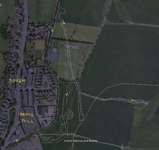
John sent me this image and asked for my comments. I hope he doesn't mind me doing it on this topic because it is of wider interest. He suspects that the LIDAR trace he has overlain on the map could be a water power site. First thing to do is look back to what I had to say about County Brook. (LINK) as it's pertinent to my reply.
Their is very little fall on the course of the water coming down from Salterforth Bottoms through Sough. (The name is the clue here!) I have little doubt that it was a very swampy piece of ground as was Salterforth Bottoms. The problem was so bad that in the3 early part of the 19th century the Salterforth electors and others joined together to find a solution to the problem. I have an idea there was a Drainage Act but can't find a reference in the index. However, this extract from the Craven Herald of 22/07/1938 is enlightening:
"Evidence of Mr John Edmondson, Skipton Road, whose father and grandfather occupied the White Lion Inn. About a century ago the low lying ground between Foulridge and Earby was a veritable swamp for most of the year and near Salterforth it was known as 'Salterforth Lake'. A Drainage Board was appointed by Government Commissioners and they met in the vestry of Thornton in Craven church. Four drains were made called Kelbrook Bottoms Drain, Earby Holmes Drain, Stone trough Drain and Lancashire Gill Drain.The reclaimed land on either side of the main stream was allotted to the neighbouring farms. From Sough Bridge to Earby, on the East side, One field went to Tunstead Farm and the next field to Moor Hall Farm. The Moor Hall Estate had a right of way on the Colne to Skipton Highway. The second field from the Earby end was formerly in two parts one of which belonged to the White Lion Inn and the other to John O' Dick's Farm which was scattered around the village (?) The first field at the bottom of Langroyd Lane belonged to the Waddington Fold Farm and was called 'Wadd Holme'. The Kelbrook portion [of the new system] was known as Kelbrook Bottoms and the Earby section as Earby Holmes. The fields on the West side of the beck were mostly allocated to White House Farm."
Bear in mind what I said above about the alterations to water flows made during the construction of Whitemoor reservoir in 1840. I don't think it is a coincidence that this initiative on the drains from Foulridge to Earby cropped up at the same time. In a nutshell, the whole of the drainage system from Salterforth Bottoms to Earby was opened up and improved and I think that the LIDAR traces on the map of Sough are the course of the original watercourse which was re-cut, straightened out and improved to get better flow around 1840. There is another factor militating against this being a water power site, there is simply not enough fall to make the effort of building a water mill worthwhile. I've just looked on the First edition OS and the realigned watercourse is shown and between Sough and Earby was given the name 'New Cut'.
Stanley Challenger Graham
Stanley's View
scg1936 at talktalk.net
"Beware of certitude" (Jimmy Reid)
The floggings will continue until morale improves!
Stanley's View
scg1936 at talktalk.net
"Beware of certitude" (Jimmy Reid)
The floggings will continue until morale improves!
-
Wendyf
- Global Moderator
- Posts: 9496
- Joined: 23 Jan 2012, 12:26
- Location: Lower Burnt Hill, looking out over Barlick
Re: EARLY SETTLEMENT IN WEST CRAVEN
I would agree with you Stanley, that area is still too flat and wet to support buildings. There are no buildings anywhere at Sough at all on the 1853 map. The traces of the meandering water course can still be seen on the ground. The water flows the opposite way to John's arrows, down the New Cut from Salterforth towards Earby, with Harden/Kelbrook Beck joining it at Sough Bridge.
There is no mention in the Thornton Manor records of there being a corn mill at Kelbrook, which is surprising, you would have thought the site of Dotcliffe Mill would have been ideal.
There is no mention in the Thornton Manor records of there being a corn mill at Kelbrook, which is surprising, you would have thought the site of Dotcliffe Mill would have been ideal.
Re: EARLY SETTLEMENT IN WEST CRAVEN
It wouldn't need to be a full time mill. A small pond plus a 2 ft drop would be enough to drive a small water wheel for a limited period of time. Such a wheel could be for domestic use only. I wouldn't discount John's idea just yet.

Re: EARLY SETTLEMENT IN WEST CRAVEN
I suppose it also depends on what you want the mill to do. For modern electric generation you'd a high fall to spin the wheel/turbine fast enough but in the old days if you wanted high torque you could do it with a low drop as long as the volume of water was large. Wheels in rivers and tidal estuaries for example. Or as Plaques hints, a body of water allowed to accumulate then let out for a period of working.
Nullius in verba: On the word of no one (Motto of the Royal Society)
-
John C Layton
- Newbie
- Posts: 54
- Joined: 09 Dec 2015, 15:57
Re: EARLY SETTLEMENT IN WEST CRAVEN
Good stuff - I was in trouble with Stanley last week for renaming the watercourses in Barlick and now I've done it again by reversing the Kelbrook waterflows! I haven't walked this area but now have a better idea of the landfall etc.
Studying the LiDAR for this area of Kelbrook I'm becoming convinced that there is a lost village here on the crossing of an ancient disused trackway from Kelbrook to Lothersdale (thanks to Wendy for pointing this out) and from Colne to Elslack. The farmstead system of Tunstead (the 'Town Head' or 'Town Stead' both of which infer a high status site within a village) appears to be very early indeed - LiDAR mapping should illustrate this.
Further to the mill question it is clear that the water at Sough Bridge would not sustain a milling operation large enough to supply a township. However, Wendy mentions Dotcliffe Mill and this would be an ideal site for a mill adjoining the lost village - over to Stanley . . .
-
Stanley
- Global Moderator
- Posts: 90859
- Joined: 23 Jan 2012, 12:01
- Location: Barnoldswick. Nearer to Heaven than Gloria.
Re: EARLY SETTLEMENT IN WEST CRAVEN
Indeed Dotcliffe would be an ideal site and it has always surprised me that there is no record that I know of of such a use. I haven't looked it up but memory says that Newton saw a water turbine there in the inter war years but it was disused at the time. I've looked at my notes on the mill and the earliest use I have found was a mention of a water powered woollen mill in the early 1800s which in 1852 was bought by Nathan Smallpage who built a new weaving shed there and owned it until the summer of 1898 when he left.
No mention of a pre-1800 use of the site but the early water powered textile mills were often on the site of existing water power sites such as corn mills because this meant the most economical transition to textiles as the ground works were already in place. So, the question remains open.....
By the way, John is not in trouble with me.... Quite the opposite. It is by raising these questions that we tease out further information and it all adds to the story.
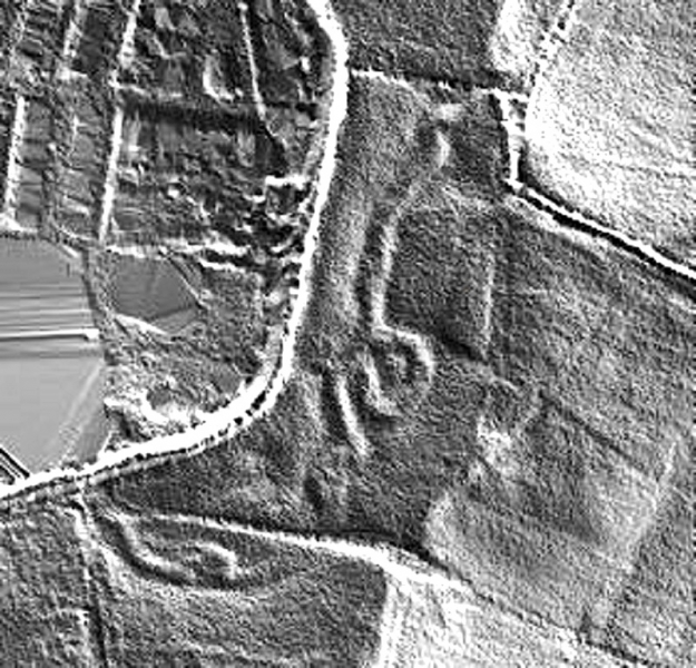
Here's the original LIDAR image that set John off.
No mention of a pre-1800 use of the site but the early water powered textile mills were often on the site of existing water power sites such as corn mills because this meant the most economical transition to textiles as the ground works were already in place. So, the question remains open.....
By the way, John is not in trouble with me.... Quite the opposite. It is by raising these questions that we tease out further information and it all adds to the story.
Here's the original LIDAR image that set John off.
Stanley Challenger Graham
Stanley's View
scg1936 at talktalk.net
"Beware of certitude" (Jimmy Reid)
The floggings will continue until morale improves!
Stanley's View
scg1936 at talktalk.net
"Beware of certitude" (Jimmy Reid)
The floggings will continue until morale improves!
-
John C Layton
- Newbie
- Posts: 54
- Joined: 09 Dec 2015, 15:57
Re: EARLY SETTLEMENT IN WEST CRAVEN

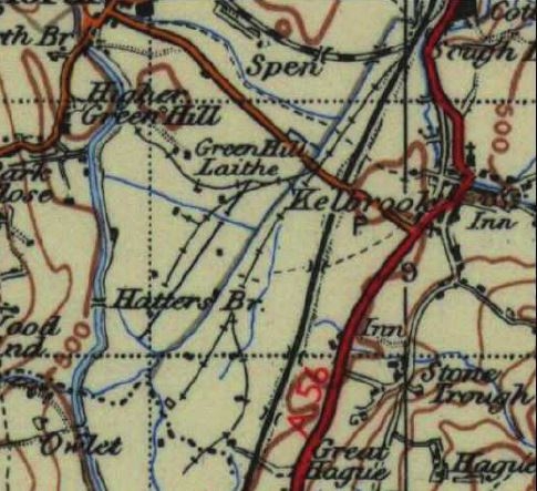
Can anyone tell me what the rectilinear feature in the image is at SD896449? Just off the main road past the ralway coming from Kelbrook. Nondiscript on LiDAR, defined by faint lines but the air image shows extended (wider) crop lines.
-
Wendyf
- Global Moderator
- Posts: 9496
- Joined: 23 Jan 2012, 12:26
- Location: Lower Burnt Hill, looking out over Barlick
Re: EARLY SETTLEMENT IN WEST CRAVEN
WW1 Cordite store in that area John. Railway sidings and nissen type huts on concrete bases. We have maps in the Earby archive.
-
Wendyf
- Global Moderator
- Posts: 9496
- Joined: 23 Jan 2012, 12:26
- Location: Lower Burnt Hill, looking out over Barlick
Re: EARLY SETTLEMENT IN WEST CRAVEN
Map showing railway sidings of cordite store at Kelbrook.
-
Wendyf
- Global Moderator
- Posts: 9496
- Joined: 23 Jan 2012, 12:26
- Location: Lower Burnt Hill, looking out over Barlick
Re: EARLY SETTLEMENT IN WEST CRAVEN
I have been told that the Salterforth sewage settlement tanks were in that position.
Re: EARLY SETTLEMENT IN WEST CRAVEN
Wendy, You've got me all confused again, Could you mark your map up with the WW1 location. I'm tending to think what John has marked up is part of the old Skipton sewage works. Of coarse this could be a load of outhouse deposit.
-
Wendyf
- Global Moderator
- Posts: 9496
- Joined: 23 Jan 2012, 12:26
- Location: Lower Burnt Hill, looking out over Barlick
Re: EARLY SETTLEMENT IN WEST CRAVEN
I got myself confused. It is the sewage works site! Apologies.
-
Stanley
- Global Moderator
- Posts: 90859
- Joined: 23 Jan 2012, 12:01
- Location: Barnoldswick. Nearer to Heaven than Gloria.
Re: EARLY SETTLEMENT IN WEST CRAVEN
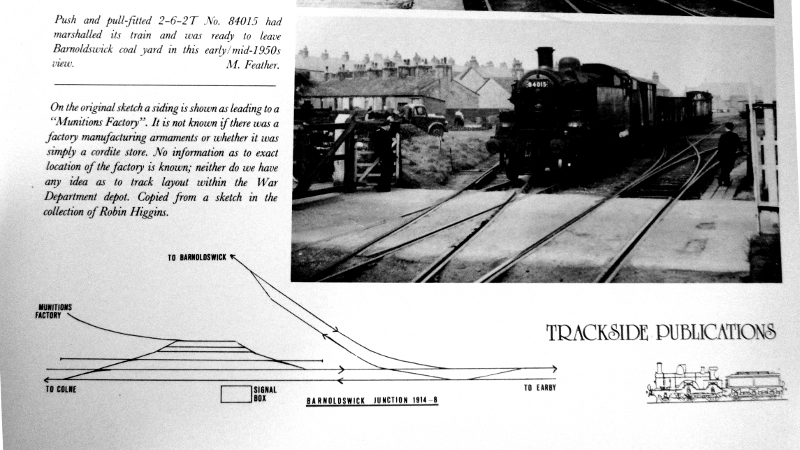
Plan of the sidings and cordite store from Donald Binns' book on the Barlick Branch railway. It's the only evidence I have ever seen on the cordite store. It has always puzzled me because I can remember seeing the brick piers which I believe were the foundations for the wooden huts at the store and they were further west in the fields between New Hague and Foulridge.
Stanley Challenger Graham
Stanley's View
scg1936 at talktalk.net
"Beware of certitude" (Jimmy Reid)
The floggings will continue until morale improves!
Stanley's View
scg1936 at talktalk.net
"Beware of certitude" (Jimmy Reid)
The floggings will continue until morale improves!
-
PanBiker

- Site Administrator

- Posts: 16561
- Joined: 23 Jan 2012, 13:07
- Location: Barnoldswick - In the West Riding of Yorkshire, always was, always will be.
Re: EARLY SETTLEMENT IN WEST CRAVEN
I think Wedy's OS map would be pretty definitive, certainly for the track layout. Sketch in the book is nothing like it, you could see all the brick foundations clearly from the cut bank at one time.
Ian
-
John C Layton
- Newbie
- Posts: 54
- Joined: 09 Dec 2015, 15:57
Re: EARLY SETTLEMENT IN WEST CRAVEN
That's sorted then - it's the sewage works - local knowledge invaluable as always.

I was interested in the feature as it lies next to the very early (Bronze Age?) trackway from Dotcliffe to Salterforth. This track was a major arterial route and ran from Ilkeley and Kildwick (via branches) to Lothersdale through Dotcliffe and Green Hill House (SE of Salterforth) to Barnoldswick Park Farm, along the line of Park Road and Gisburn Road to Crook Carr and straight up to Stock Village, along to Horton and then to the ford at Nappa. It crossed a number of ancient trackways, many of which are described as 'Roman' roads, and illustrates the important position of towns and villages (Kelbrook, Barnoldswick, Stock, Horton etc.) within the prehistoric trading routes and within the Romano-British/Anglo-Saxon settlement systems. When this route fell out of use the smaller townships diminished and the population migrated to the villages where natural advantage allowed for the support of a rising population - such as Barlick with its water power system, viable farm land, plentiful supply of timber and the political will of an overlord to allow or encourage migration. So we see that the established villages of Kelbrook,Stock, Horton, Ingethorpe, Newsholme etc. are now nothing other than small groups of scattered farmsteads.
The image shows the trackway through Barlick with another major track to the west (this ran directly from the 'Roman' road that dropped into Gisburn, through Bracewell, Monkroyd Hill and down to Burdock Hill (where it now disappears). Looking at the town layout now it is possible to propose a rough area of pre-Norman settlement for Barlick (highlighted in image) - this incorporates a possible Bronze/Iron Age farmstead enclosure with Hey Farm on its SE periphery.
The image shows the trackway through Barlick with another major track to the west (this ran directly from the 'Roman' road that dropped into Gisburn, through Bracewell, Monkroyd Hill and down to Burdock Hill (where it now disappears). Looking at the town layout now it is possible to propose a rough area of pre-Norman settlement for Barlick (highlighted in image) - this incorporates a possible Bronze/Iron Age farmstead enclosure with Hey Farm on its SE periphery.
-
Stanley
- Global Moderator
- Posts: 90859
- Joined: 23 Jan 2012, 12:01
- Location: Barnoldswick. Nearer to Heaven than Gloria.
Re: EARLY SETTLEMENT IN WEST CRAVEN
Interesting, the westerly route goes straight through Windy Harbour, the small group of houses in the triangle of land opposite Bancrofts Farm (Bank Crofts). That name is common and is associated with drove routes and pack horse way stations.
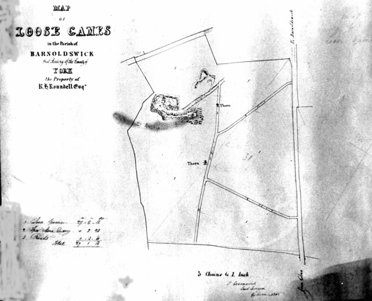
This piece of land, Loose Games', on the same line as the western route, at the corner of Lister Well Lane and High Lane at Upper hill has always intrigued me. I smell something there of an earlier date than the quarry which was also known as Loose Games and was later greatly enlarged. This is from some estate maps connected with the Roundells of Gledstone.
The easterly route where it crosses the line of the old Blue Pot Lane (Now Park Avenue) and goes down what is now Park Road and Frank Street offers a possible explanation for the sudden left turn on the old route down from Weets, through Causeway Carr and forward along Long Field lane to Park Avenue, a feature which has long puzzled me. A right turn down Rainhall Road sets the old track on course again for Gill Church and forward to Kildwick and the Aire Gap. Could the area around Frank Street have been an overnight halt on the trackway? Hence what looks like a diversion? Or was the Weets track just avoiding boggy ground in the bottoms beyond where the railway line runs on this map. This, and more accurately the line of the canal, is the line of very wet bottom land extending east from Foulridge.
Fascinating stuff. Keep the conversation going!
Stanley Challenger Graham
Stanley's View
scg1936 at talktalk.net
"Beware of certitude" (Jimmy Reid)
The floggings will continue until morale improves!
Stanley's View
scg1936 at talktalk.net
"Beware of certitude" (Jimmy Reid)
The floggings will continue until morale improves!