OK, not all , but there have been design changes through the years of some of what might be recognised , for generally being in London , Stations on the Deep Tube and/or the Sub Surface Lines.
It could be taken for granted that everyone knows that the First Underground Railway in the World was the Metropolitan Line, two broad gauge tracks from Paddington To Moorgate , an approximate line of the above ground "New Road" , later Marylebone Road / Euston Road / City Road that was also broadly Mr Shillibeer's first Omnibus route in London - a single deck box on wheels hauled by three abreast horses.
Designed to be operated in conjunction with the Great Western Railway that company fell out leaving the Met on its own. Extensions of the Line followed , to the west via Royal Oak and Latimer Road to Hammersmith , much of which was built on a viaduct allowing for letting of the arches for income and to the east in more "cut and cover" or shallow cuttings , to Aldgate via Liverpool Street and to Aldgate East where further late developments sent it to Upton Park and Barking ,using tracks of the London Tilbury and Southend Railway that were "spare" local stopping services. A northwestern extension , from Baker Street - which would be the HQ of the Metrolpolitan - would create Metro-Land - places like Moor Park, Watford , Amersham and at one time , with a more happy relationship with the London Extension of the Manchester, Sheffield and Lincoln railway as the Great Central with services from Aylesbury and other bits of Buckinghamshire , bits of which exist as Chiltern Railways today (and East-West rail upcoming in small amount, and indeed HS2 trackbed in spirit and sometimes body). Shorter extensions would get to Stanmore in then Middlesex and an ambitious expansion of financial interests in the Northern City Line - Finsbury Park to Moorgate , disconnected generally from the rest of its network and the East London Line passenger services using the Brunel Foot Tunnel under the Thames at Rotherhithe, that had already been adapted by lines out of the The Great Eastern Railway Liverpool Street Station to the likes of the London Brighton and South Coast stations in Peckham and Crystal Palace among a myriad of others. A connection near Whitechapel joined the Met to the East London. The Metropolitan could also run accross the passenger concourse at Liverpool Street to the Great Eastern Railway lines , but maybe not surprisingly this didnt really work well and was ceased.
The Metropolitan encouraged the building of the Metropolitan District Railway , or District Line, to build much along the south part of central london - helped by the Metropolitan Board of Works construction of the Embankments of the Thames including new super sewers to take liquid waste out of flowing into the Thames - well at least till Abbey Wood and Crossness where a falling tide could carry the problem away to Essex. The District didnt have much money and actually getting the job done was difficult and the District also went to get running powers over other lines that would give it services from Windsor via Slough to Southend on Sea once a short line via Stepney Green would connect with the London and Tilbury Route. Eventually running powers with the London and South Western would take the District to Richmond, Wimbledon and with the GWR of sorts to Ealing Broadway along with its own route to Hounslow.
Deep Tubes , if we exclude the Tower pneumatic railway - the Tower Subway , from Tower Hill to the other side of the Thames ( smelly and unreliable its tunnel would to this day carry comms and electric cables ). The City and South London Railway from Kennington (later Clapham Common ) to King William Street had a success that saw the Central London Railway (the tuppeny tube) run from Shepherd's Bush to Bank, where it would meet the London and South Western oddity of a single route of Waterloo to City via its deep level tunnel, this line lasted into the Southern Railway as part of the grouping in 1923 of most of Britains Railways ( the Metropolitan keeping out of things and managing to be independent ) . Later lines would be promoted , the Highgate Railway - that would later become effectively the West End Branch of the Northern Line , extensions of a rebuilt City and South London tube to a wider bore and rolling stock size to head north via Old Street, Angel , Kings Cross and Euston to join at Camden Town the twin arms of the Highgate railway and forge on to the open fields of Golders Green. The mouthful of Piccadilly , Brompton and ? Finsbury Park ? (I can never remember the name) was folded into ideas of the District Line for fast journeys on a deep line along part of its length such that Hammersmith via Earls Court onto Piccadilly , Kings Cross and Finsbury Park would happen , much under ideas of financing and electrification via the Lots Road Power station designed by former Chicago based Charles Yerkes, who brought US methods of running railways to the tube in part leading to why Underground Carriages are called Cars, Yerke's finances would eventually bring what would be in due course the Northern , The Picadilly and The Baker Street and Waterloo railway- Bakerloo into one Organisation - Underground Electric Railways of London. Yerkes died before much of the lines could be built and creditors found there was more hole than money and saught the services of Albert Stanley to pull things together , Stanley would later become Lord Ashfield , and along with Commercial Manager Frank Pick would expand The Underground (UERL) into holding tramway companies like London United in the South west of London , and the rather massive London General Omnibus Company. The earlier separation of competing lines had meant many locations had separate stations including , as may have been noted the Inner Circle (via High Street Kensington) and Middle Circle (via Latimer Road and Olympia/Addison Road ) (there was an outer circle not part of the group as such which wasnt a circle but sort of ran over the North London Railway lines to places like Richmond ) South Kensington would have separate ticket halls for District ,running anti-clockwise around the circle and Metropolitan running clockwise. Eventually sense prevailed and joint ticketing was created and the District would join the underground group, but not before the Picadilly line station was built in the ox-blood facing style that the Underground group adopted for its stations. Some key interchanges would look different - with The Central London at Oxford Circus having a tall station building with the upper floors as offices - indeed these would be that railway s admin HQ, while adjacent was the Bakerloo Entrance in the ox blood style. again with offices above. Indeed even when a single storey station was built its design was to have buildings above in many cases either as residential or offices. Most stations were designed with lifts for access ground level to the platforms metres below ground. Many would be supplanted by escalators - which meant passenger halls moved often to locations with no striking above ground structures and the foot subway often crossing the busy roads of London became purposed as the station entrance - Hyde Park Corner being perhaps the most notable , or Green Park which replaced entirely Down Street Station (used then as offices for govt in WW2).
Frank Pick considered that Stations should be bold and stand out in their area (something with the building above of some offices rather reverse) with the extensions to Piccadilly and Northern Lines in the either the Concrete Box with a lid on style of Charles Holden as architect finished with a red brick facing or the same architect's style for Northern Line extensions in a neo classical portland stone clad style , with the southern section differing in detail compared with northern places as Edgeware and Hendon Central. In 1924 road services in London became licenced London wide which gave the underground group in the end more opportunities to consolidate but the tube network remained marketed as Underground , and incorporated the Central London Railway too. In early 1933 after a commission on transport generally and earlier ideas of what should happen in London as the London County Council had already been estabished and the Metropolitan Board of Works had alread got sewage and much water supply in London under its control a quasi public corporation The London Passenger Transport Board was formed , this acquired The Underground Group, The Metropolitan Railway and further bus operators such as Tilling in London , Birch Brothers London area services and regular coach services such as those of Hillman of Romford along with company and local authority Tram services . In a backdrop of a recession in the country government grants for capital works meant more planning for new line extensions along with new rolling stock for the lines and more electrification of the Metrolpolitan Line. Other ideas to take on more commuter lines of the big 4 main railways along with some parts of the Metropolitan passing to the LNER as sucessor to the Great Central Railway.
Ashfield and Plck would continue as generally running the organisation up until the early years of WW2 and a trading name of London Transport Was Established.
This set of transistion years gave rise to some rather strange design quirks as the general visitor to London , certainly in the 1960s and still today may see what appears to be timeless in design of "underground" in the roundel/bulls eye with similar for station names at street and platform level , but a bit of viewing over photographs (and alas missing many that would have answered some queries for some locations ) I dont propose to cover every detail encompassed in the very brief history foregoing but a few bits I found of passing interest.
A Typographical Review of London Underground Stations
-
Whyperion

- Senior Member
- Posts: 3748
- Joined: 23 Jan 2012, 22:13
- Location: Back In London as Carer after being in assorted northern towns inc Barnoldswick, Burnley, Stockport
Re: A Typographical Review of London Underground Stations

A bit small , but it is representative , but not so. Rather overspecified for its location, Kilburn Park was almost rural in Edwardian days with "upstairs downstairs" terraced houses around much of the area. Unusual I think is the over arch to the entrance though this could double up as a shelter for a bus stop.
I think the building to the rear was part of the Bakerloo Line electricity supply transformers , Kilburn Park was the northern most station but not the end of the line, as next along was Queen's Park where a depot was built but at the same time the station was owned and built by the London and North Western Railway . later LMS. Bakerloo line trains would run at one time to Watford High Street and Watford Junction via Bushey , but Harrow and Wealdstone is now the northern extent of the Bakerloo's activities , with the now London Overground covering the rest of the rout with its service out of London Euston . In later days of British Railway's Network South East and early privatisation to "Silverlink trains" the Watford BR service was known as the Harlequin Service with a colourful logo for it , under the Overground it is dubbed the Lioness line after the Womens' FA England Football team successes at Wembley Stadium.
In the picture view there is little of the styled roundel with an UndergrounD picked out on the tiling and the cast shape typeface for the likes of Exit, not even the line name has any prominance but we can see the space left for offices or whatever. I think this was designed wholly as escalators only as they go straight from the booking hall (machines only like the rest of the present day tube network with in this case more history panels in the old serving windows but also some as glass vivariaum? ornamental plant displays, to the mid point of the platforms.
Many of the Bakerloo and similar lines had lifts and more speciically a short flight of stairs onto one end of the platforms , this makes either a long walk if you get your exit from the train wrong , or crowding at the foot of the stairs. Over the years some have been modified particulary as the likes of the connecting Victoria Line was built. However even the new Elizabeth Line station at Abbey Wood in SE London has the same problem being built with only three escalators and a small lift at one end due to cost saving on the station build , but there is some scope to add either exit in middle area of station via a mezzanine , or with relocating some of the plant room , an exit at the other end via the basement of any proposed adjacent build of offices or residences. Similar but planned with two exits and the second recently put into use is the Northern Line extension to Battersea Power Station - which needed it as the numbers using the station now and more housing planned is really pushing modern elbow room to the limit. The cost "saving" in the political stop start money tap of course being seen with HS2 (north segment) /Northern Powerhouse rail
Last edited by Whyperion on 27 Oct 2025, 22:02, edited 2 times in total.
-
Whyperion
- Senior Member
- Posts: 3748
- Joined: 23 Jan 2012, 22:13
- Location: Back In London as Carer after being in assorted northern towns inc Barnoldswick, Burnley, Stockport
Re: A Typographical Review of London Underground Stations

A busy probably bank holiday , the bus probably going somewhere like Pariiament Hill Fields or Hampstead Heath and would have been cheaper and more direct.
the "Johnson" form of typescript that would generally be come to be used in the Underground Group I am not expert enough to identify , I think the lettering here is of an early weight and sizing

Last edited by Whyperion on 27 Oct 2025, 21:23, edited 1 time in total.
-
Whyperion
- Senior Member
- Posts: 3748
- Joined: 23 Jan 2012, 22:13
- Location: Back In London as Carer after being in assorted northern towns inc Barnoldswick, Burnley, Stockport
Re: A Typographical Review of London Underground Stations

A later (1950s ?) probably Christmas Day or early on a Sunday , and the rear of the site has gained modern higher rise flats, I think these have recently been subject to Gentrification as new slighly higher mansion blocks. The station entrance canopy is much simplified but we can see how the old curved structure nestled in the curve of the window header structure
Lower glazing or panel area X crossbars appear to have been covered up with painted (timber?) panels - a left over from WW2 protection or some oddities of the maintenance dept
The lampshades have also lost their rectangular lower vertical additions on the six sides of the hexagons
Last edited by Whyperion on 27 Oct 2025, 22:00, edited 2 times in total.
-
Whyperion
- Senior Member
- Posts: 3748
- Joined: 23 Jan 2012, 22:13
- Location: Back In London as Carer after being in assorted northern towns inc Barnoldswick, Burnley, Stockport
Re: A Typographical Review of London Underground Stations
More for Kilburn Park to come , it gets even more confusing
 advert for proposed opening dates

Warwick Avenue , Kilburn Park and Queen's Park opened early in 1915 as stations on the Bakerloo Line. Queen's Park was already a London and North Western Railway station on its commuter line/s to Watford (now Overground services )(and later LMS)effectively beyond) from Euston. The Bakerloo also built a new depot and running shed at Queen's Park and most services terminate there still - having been in the past as far as Watford too but the Bakerloo manages erractically to get to Harrow and Wealdstone station these days. Queen's Park has a bit of an oddity as Bakerloo trains run south toward Euston on a non-passenger section , to clear point work for accessing depot from some running roads and clearing the line for other train movements (about once or twice as day). This depot was in addition to the existing one just north of Elephant and Castle at Lambeth in SE London.


X cross features have been revealed again and the housing in the distance changed (wartime damage or 1950s demolition happy times ?) The two small street facing kiosks I think was a local pharmacy and they extend for a short distance back into the station building but not that much and there is an unseen underground staff's office at the far end of the kiosk area which is part of it
External Lighting is a Hexagonal profile of shade with trapizium side panels. A style not uncommon on the underground but widths of the panels and their angles to vertical vary
Interesting pair of telephone kiosks on the pavement one normal pay money the other I think takes cards
advert for proposed opening datesWarwick Avenue , Kilburn Park and Queen's Park opened early in 1915 as stations on the Bakerloo Line. Queen's Park was already a London and North Western Railway station on its commuter line/s to Watford (now Overground services )(and later LMS)effectively beyond) from Euston. The Bakerloo also built a new depot and running shed at Queen's Park and most services terminate there still - having been in the past as far as Watford too but the Bakerloo manages erractically to get to Harrow and Wealdstone station these days. Queen's Park has a bit of an oddity as Bakerloo trains run south toward Euston on a non-passenger section , to clear point work for accessing depot from some running roads and clearing the line for other train movements (about once or twice as day). This depot was in addition to the existing one just north of Elephant and Castle at Lambeth in SE London.
X cross features have been revealed again and the housing in the distance changed (wartime damage or 1950s demolition happy times ?) The two small street facing kiosks I think was a local pharmacy and they extend for a short distance back into the station building but not that much and there is an unseen underground staff's office at the far end of the kiosk area which is part of it
External Lighting is a Hexagonal profile of shade with trapizium side panels. A style not uncommon on the underground but widths of the panels and their angles to vertical vary
Interesting pair of telephone kiosks on the pavement one normal pay money the other I think takes cards
Last edited by Whyperion on 27 Oct 2025, 22:17, edited 11 times in total.
-
Whyperion
- Senior Member
- Posts: 3748
- Joined: 23 Jan 2012, 22:13
- Location: Back In London as Carer after being in assorted northern towns inc Barnoldswick, Burnley, Stockport
Re: A Typographical Review of London Underground Stations

Kilburn and Brondensbury, (Christchurch Avenue Entrance) North West London. I will do a history later, but of note is the UndegrounD (to anywhere) poster panels. Though UERL was its own company the UndergrounD name was created along with the Metropolitan Railway as a marketing name for the rail services of the two grounds as a whole including station signage, maps and advertising posters for the companies.
There is also part of the "Three Sided" vertical box that was used for a while - sometimes as three sides of a square (with a mounting bracketry side against the wall, or two panels meeting at a triangle point
I think the advert for the "Bell" Telephone predates General Post Office Telephones - the railway companies had their own phone system and exchanges but I dont know about public interconnects , if any , or what systems specifically were promoted - anyone further ideas ?
Sep 1933

Jul 1935

May 1939

Dec 1939


Last edited by Whyperion on 28 Oct 2025, 01:09, edited 9 times in total.
-
Whyperion
- Senior Member
- Posts: 3748
- Joined: 23 Jan 2012, 22:13
- Location: Back In London as Carer after being in assorted northern towns inc Barnoldswick, Burnley, Stockport
Re: A Typographical Review of London Underground Stations
Perhaps we should have a map ,or two, to look at.
Before Harry Beck suggested his diagram style to the Underground Group, Fred Stingemore had been asked to come up with a design , but this is not it , I am not sure who did the design work

Indeed perhaps I should look at things like opening dates of some stations - until I get bored
I could probably write for hours on this map - and indeed maybe replace the image with a slightly better one/s. As to date it is before 1915 (I will get better later)
What I rather like is the Box drawn out for the main line stations but in the line colour of the underground lines serving them.
For anyone that knows the present day map colours of Tube lines will note some are different on these early maps. I am not sure if some of the inscriptions on the map were light printing , a private individual adding notes or a working employee adding notes
Mainline Stations - pre the 1923 Grouping
Victoria - South Eastern and Chatham Railway , London Brighton and South Coast Railway. Indeed at one time one would see buses going to "Victoria Stations" which , District and Circle lines aside the main lines had built a station each ,adjoining , and it would be some years before the dividing wall removed allowing passengers to move between the two sides without going out onto the external roadways and footpaths.
Paddington - Great Western Railway. Somewhat more accurately the underground lines have their own names - Bishop's Road for the Metropolitan (Present day Paddington of the Circle and Hammersmith and City, Praed Street - which despite being red for the Metropolitan saw circle line (earlier joint service ) of the Metropolitan District Line , and is the present day Paddington Station of the District and Circle Lines. Which as now the Circle line is not a circle but more of a bootlace shape means a circle line train will leave Hammersmith and pass through Paddington (indeed the platforms are virtually part of Paddington main line station though with a gateline separation) thence Edgware Road then around the clockwise looping to via High Street Kensington pass again at a lower level with stairs up to the south side of the mainline station Paddington Station again this time to terminate at bay platforms at Edgware Road. Paddington has not yet been reached by the Bakerloo Line - nor (and announced today more new build trains for it) the Elizabeth Line - both would get their own stations where subway passageways would be quite a route distance for the unwary passenger trying or needing to interchange.
Marylebone - Great Central Railway indeed the Bakerloo station would initially be known as Great Central on the first of its westward extensions from Baker Street . The Edgware Road stations are not that much of a walk from Paddington really ( nor , and here is a hint, Lancaster Gate on the Central Line for a what used to be slightly quicker to some places east via that line if arriving from the west. Oxford, or the sometimes Birmingham services to Paddington. The now A40 road splits the two Edgware Road Stations off with the Bakerloo to the north , and a set of passenger traffic lights accross 4 lanes of local traffic take you under the last of the Westway flyover at ground level to make a left turn to the street where the District , Hammersmith and City and Circle nowadays Edgeware Road station lies.
We will give a honoury mention to Baker Street station as main line station as its northern extention Metropolitan Route ( first created as a single track line to Swiss Cottage presumably calling at St John's Wood Road and Marlborough Road ) met argueably the World's first Purpose Built underground station ( ok it takes two to make a line , but given Paddington was effectively an extention of the GWR and indeed the GWR were supposed to operate the line built to Baker Street (but gave up and fell out with the Metropolitan pretty quickly despite the line having broad guage capability). Euston on the Metropolitan i will have to check - it is now Euston Square and only gettable to the main line by using street level footpaths by the now very busy Euston Road. The London and North Western Railway station much modified in BR Modernisation times but the line approaches in a cutting from those odd places like Crewe, Manchester and Glasgow, leaving passengers with a trek with luggage up a slope to find the external bus station of sorts or a taxi rank or for the bold a walk toward Russell Square or the British Museum. The city and south london railway I dont think ever had a surface level building at Euston - its stairs just appeared in the circulating area of the main line station , indeed after BR changed the station Deltic Diesels would noisily fume much of the main line platforms . The Highgate Railway's Euston Station would be a little to the west of the mainline station having a Leslie Green designed station building (recently demolished for HS2 arrival) but it would end up being slightly east of the City and South London's tunnels to sweep around to meet the highgate lines at the complex Camden Town junctions and station.
St Pancras would be the London Terminal of the Midland Railway ( well not the only one as such ) having shared uncomfortably facilities with the likes of the LNWR at Euston and the GE at Kings Cross. Boldly crossing into Somers Town area on a brick built viaduct the taxi and carriage road was up a slope from the Euston Road's north side , reminding me of Manchester Piccadilly in some ways. Only ever getting at best an "and"second billing to the Great Northern Railway's King's Cross station at an area one time known as Battlesbridge (I think there had been a civil war skirmish there). Tube services of the extended City and South London Line interweaved under ? the Great Northern , Piccadilly and Brompton Railway and again there was little long lived of surface buildings of substance , the Metropolitan Line being a little further west around the low end of Pentonville Road before some joining of the Midland Railway to run on the "Widened Lines" to run to Moorgate with the Bedpan service being the 1970s BR commuter service before longer Thameslink trains would mean the corner at Farringdon was no longeraccessible.
The Metropolitan reached intially Farringdon Street before going west to Moorgate and an apparently unnamed Liverpool Street I dont think the map is so early , but might be as the Great Eastern Railway passengerterminal was at Bishopsgate before turning in a low cutting to the Liverpool Street terminus a couple of hundred yards closer to the Bank of England via a choice of walking or bus routes - depends if it was raining or not. The later central line extension would bring a closer station exit to Broad Street Station of the North London Railway. The North London rarely ran its own trains , being a route that leased its metals to whichever operators wanted to travel over the line built - mainly freight to other frieght stations , an ever changing choice of destinations eventually fell to nil and the station closed and demolished in the 1980s by British Rail . The Metropolitan had a surface rail connection to the Great Eastern at Liverpool Street but annoying passengers on the concourse and making an already tricky to run circle service even worse that was ceased. No connector box for Fenchurch Street owned by the Great Eastern Railway , but for many years the London Tilbury and Southend Railway would run the main passenger services into it via the Limehouse route, The Great Eastern would sometimes take a Poplar route from Stratford but one line was ceased completely another rare and another would become part of the docklands light railway.
London Bridge was another split station of the London Brighton and South Coast's low level terminating trains in the main and the through trains on a viaduct of what had been the earliest passenger railway into London , the London and Greenwich railway , later incorporated into the South Eastern and Chatham Railway (formed of the London Chatham and Dover Railway and the South Eastern Railway). Bridges over the Thames would bring via a various spaghetti network across south london , Canon Street , Blackfriars (which the District railway called its station St Pauls ) ( the present day Central Railway station St Pauls was known as Post Office on this map) , and Charing Cross (via Waterloo East which is not shown on this map) Waterloo for the London and South Western railway I think completes the circuit (perhaps Farringdon should have been included but services to Blackfriars via Snow Hill Tunnel are confusing - and we have missed Holborn Viaduct but that is confusing too and not directly served by an underground line ). The LSWR would also effectively own the Waterloo and City tube line (the 2nd to be built in London ) where indeed it is shown on this map , this time to the Central Line and City and South London Railway complex known as "Bank".
Oh , I missed Finsbury Park , the Northern City Line was built to take the mainline suburbans to moorgate , but that never happened and the line was acquired by the Metropolitan Railway, only many years later - following a LPTB transfer to Northern Line would services from Herford and Cambridge would take over.
Non Railway Features on the Map
Agricultural Hall at Islington , always looked as if it should have been a railway trainshed the exhibition hall having a single span curved roof, served by Underground at Angel,Islington Station. Its compatriot in West London at Olympia (now Oiympia One) was if anything even larger in its coverage , often used by visiting Circuses and the likes of Buffalo Bill's Wild West Show. Earls Court I dont know if that was the 1930s halls I remember and the Shepherds Bush Exhibition was effectively White City (so called because of the colour of many of the buildings.I think it was 1912 for its big show , which saw the Central London Railway extend to the showground and part I think used for the London Olympics. Parts in the future would become the site of BBC Television Centre opp Wood Lane Central Line Station and the White City Stadium for Greyhounds and Speedway , part of the White City housing estate ( 1930s to 1950s ) and much more recent Westfield Shepherd's Bush Shopping centre
Before Harry Beck suggested his diagram style to the Underground Group, Fred Stingemore had been asked to come up with a design , but this is not it , I am not sure who did the design work
Indeed perhaps I should look at things like opening dates of some stations - until I get bored
I could probably write for hours on this map - and indeed maybe replace the image with a slightly better one/s. As to date it is before 1915 (I will get better later)
What I rather like is the Box drawn out for the main line stations but in the line colour of the underground lines serving them.
For anyone that knows the present day map colours of Tube lines will note some are different on these early maps. I am not sure if some of the inscriptions on the map were light printing , a private individual adding notes or a working employee adding notes
Mainline Stations - pre the 1923 Grouping
Victoria - South Eastern and Chatham Railway , London Brighton and South Coast Railway. Indeed at one time one would see buses going to "Victoria Stations" which , District and Circle lines aside the main lines had built a station each ,adjoining , and it would be some years before the dividing wall removed allowing passengers to move between the two sides without going out onto the external roadways and footpaths.
Paddington - Great Western Railway. Somewhat more accurately the underground lines have their own names - Bishop's Road for the Metropolitan (Present day Paddington of the Circle and Hammersmith and City, Praed Street - which despite being red for the Metropolitan saw circle line (earlier joint service ) of the Metropolitan District Line , and is the present day Paddington Station of the District and Circle Lines. Which as now the Circle line is not a circle but more of a bootlace shape means a circle line train will leave Hammersmith and pass through Paddington (indeed the platforms are virtually part of Paddington main line station though with a gateline separation) thence Edgware Road then around the clockwise looping to via High Street Kensington pass again at a lower level with stairs up to the south side of the mainline station Paddington Station again this time to terminate at bay platforms at Edgware Road. Paddington has not yet been reached by the Bakerloo Line - nor (and announced today more new build trains for it) the Elizabeth Line - both would get their own stations where subway passageways would be quite a route distance for the unwary passenger trying or needing to interchange.
Marylebone - Great Central Railway indeed the Bakerloo station would initially be known as Great Central on the first of its westward extensions from Baker Street . The Edgware Road stations are not that much of a walk from Paddington really ( nor , and here is a hint, Lancaster Gate on the Central Line for a what used to be slightly quicker to some places east via that line if arriving from the west. Oxford, or the sometimes Birmingham services to Paddington. The now A40 road splits the two Edgware Road Stations off with the Bakerloo to the north , and a set of passenger traffic lights accross 4 lanes of local traffic take you under the last of the Westway flyover at ground level to make a left turn to the street where the District , Hammersmith and City and Circle nowadays Edgeware Road station lies.
We will give a honoury mention to Baker Street station as main line station as its northern extention Metropolitan Route ( first created as a single track line to Swiss Cottage presumably calling at St John's Wood Road and Marlborough Road ) met argueably the World's first Purpose Built underground station ( ok it takes two to make a line , but given Paddington was effectively an extention of the GWR and indeed the GWR were supposed to operate the line built to Baker Street (but gave up and fell out with the Metropolitan pretty quickly despite the line having broad guage capability). Euston on the Metropolitan i will have to check - it is now Euston Square and only gettable to the main line by using street level footpaths by the now very busy Euston Road. The London and North Western Railway station much modified in BR Modernisation times but the line approaches in a cutting from those odd places like Crewe, Manchester and Glasgow, leaving passengers with a trek with luggage up a slope to find the external bus station of sorts or a taxi rank or for the bold a walk toward Russell Square or the British Museum. The city and south london railway I dont think ever had a surface level building at Euston - its stairs just appeared in the circulating area of the main line station , indeed after BR changed the station Deltic Diesels would noisily fume much of the main line platforms . The Highgate Railway's Euston Station would be a little to the west of the mainline station having a Leslie Green designed station building (recently demolished for HS2 arrival) but it would end up being slightly east of the City and South London's tunnels to sweep around to meet the highgate lines at the complex Camden Town junctions and station.
St Pancras would be the London Terminal of the Midland Railway ( well not the only one as such ) having shared uncomfortably facilities with the likes of the LNWR at Euston and the GE at Kings Cross. Boldly crossing into Somers Town area on a brick built viaduct the taxi and carriage road was up a slope from the Euston Road's north side , reminding me of Manchester Piccadilly in some ways. Only ever getting at best an "and"second billing to the Great Northern Railway's King's Cross station at an area one time known as Battlesbridge (I think there had been a civil war skirmish there). Tube services of the extended City and South London Line interweaved under ? the Great Northern , Piccadilly and Brompton Railway and again there was little long lived of surface buildings of substance , the Metropolitan Line being a little further west around the low end of Pentonville Road before some joining of the Midland Railway to run on the "Widened Lines" to run to Moorgate with the Bedpan service being the 1970s BR commuter service before longer Thameslink trains would mean the corner at Farringdon was no longeraccessible.
The Metropolitan reached intially Farringdon Street before going west to Moorgate and an apparently unnamed Liverpool Street I dont think the map is so early , but might be as the Great Eastern Railway passengerterminal was at Bishopsgate before turning in a low cutting to the Liverpool Street terminus a couple of hundred yards closer to the Bank of England via a choice of walking or bus routes - depends if it was raining or not. The later central line extension would bring a closer station exit to Broad Street Station of the North London Railway. The North London rarely ran its own trains , being a route that leased its metals to whichever operators wanted to travel over the line built - mainly freight to other frieght stations , an ever changing choice of destinations eventually fell to nil and the station closed and demolished in the 1980s by British Rail . The Metropolitan had a surface rail connection to the Great Eastern at Liverpool Street but annoying passengers on the concourse and making an already tricky to run circle service even worse that was ceased. No connector box for Fenchurch Street owned by the Great Eastern Railway , but for many years the London Tilbury and Southend Railway would run the main passenger services into it via the Limehouse route, The Great Eastern would sometimes take a Poplar route from Stratford but one line was ceased completely another rare and another would become part of the docklands light railway.
London Bridge was another split station of the London Brighton and South Coast's low level terminating trains in the main and the through trains on a viaduct of what had been the earliest passenger railway into London , the London and Greenwich railway , later incorporated into the South Eastern and Chatham Railway (formed of the London Chatham and Dover Railway and the South Eastern Railway). Bridges over the Thames would bring via a various spaghetti network across south london , Canon Street , Blackfriars (which the District railway called its station St Pauls ) ( the present day Central Railway station St Pauls was known as Post Office on this map) , and Charing Cross (via Waterloo East which is not shown on this map) Waterloo for the London and South Western railway I think completes the circuit (perhaps Farringdon should have been included but services to Blackfriars via Snow Hill Tunnel are confusing - and we have missed Holborn Viaduct but that is confusing too and not directly served by an underground line ). The LSWR would also effectively own the Waterloo and City tube line (the 2nd to be built in London ) where indeed it is shown on this map , this time to the Central Line and City and South London Railway complex known as "Bank".
Oh , I missed Finsbury Park , the Northern City Line was built to take the mainline suburbans to moorgate , but that never happened and the line was acquired by the Metropolitan Railway, only many years later - following a LPTB transfer to Northern Line would services from Herford and Cambridge would take over.
Non Railway Features on the Map
Agricultural Hall at Islington , always looked as if it should have been a railway trainshed the exhibition hall having a single span curved roof, served by Underground at Angel,Islington Station. Its compatriot in West London at Olympia (now Oiympia One) was if anything even larger in its coverage , often used by visiting Circuses and the likes of Buffalo Bill's Wild West Show. Earls Court I dont know if that was the 1930s halls I remember and the Shepherds Bush Exhibition was effectively White City (so called because of the colour of many of the buildings.I think it was 1912 for its big show , which saw the Central London Railway extend to the showground and part I think used for the London Olympics. Parts in the future would become the site of BBC Television Centre opp Wood Lane Central Line Station and the White City Stadium for Greyhounds and Speedway , part of the White City housing estate ( 1930s to 1950s ) and much more recent Westfield Shepherd's Bush Shopping centre
-
Whyperion
- Senior Member
- Posts: 3748
- Joined: 23 Jan 2012, 22:13
- Location: Back In London as Carer after being in assorted northern towns inc Barnoldswick, Burnley, Stockport
Re: A Typographical Review of London Underground Stations
Interesting Stations and a rough order of tube station designing (in progress)
I will probably leave most of the Metropolitan Line north of Baker Street - there were changes in stations and names followed by take over of the local stations in the 1920s by a second branch of the Bakerloo Line Baker Street to Stanmore - with a depot at Neasden - now part of the Jubilee Line ( which much extended does its long U bend under the thames to hit south east London, docklands then to Stratford , Essex - well now East London - with another depot on the site of Stratford Market (Fruit and Veg - how many fruit and veg markets did London need - answer in those days of rail transport from the docks or fields of Suffolk , quite a few to feed the population in the days before frozen and chilled distribtion.
Starting in the West and the red line for Metropolitan , This ran over District toward Hounslow / Ealing if I read the map correctly. leaving via the Hammersmith Grove curve , the red blob I think was Hammersmith Grove Station to Distinguish from Hammersmith - which was part of the extension west from Paddington for the Metropolitan Railway in conjunction with the GWR who they had become friends with again. Shepherd's Bush more recently named Shepherd's Bush Market which is more accurate in a way - the market ,part under the arches of the Met line is at the commercial end of the locality , with the rather large Shepherds Bush Green (the Shepherds Bush Empire Cinema and BBC Theatre being on the west side thereof) separating a bit of a walk from the Central Line Station (I lost the photos I took of that before it was much rebuilt in a modern aluminum style). Missing is Goldhawk Road station , which forms the other end of Shepherds Bush Market. Stations would come and go in part due to plaforms being wooden , cantilevered off the upper abutments of the viaduct with fairly simple ticket purchasing facilities. Wood Lane on the Met would disappear for some years leaving Latimer Road as the next stop, It was reinstated when Westfield shopping city came along . I will have to check Notting Hill as it went in part to avoid confusion with Notting Hill Gate its now Ladbroke Grove and is the nearest station for Grenfell Tower (currently being demolished), I mentioned some of the changes of that area planned and unfullfilled as the West Link Road and motorway box plans of London changed large housing plans , squished others and left London affected even as most of the plans dropped away , Westborne Park exists adjacent too the A40 westway , Royal Oak is walkable to Paddington , which Royal claimed or used the oak I dont know , but the station is named after a pub that pre-existed it - a few underground stations are named after pubs.
Addison Road to Latimer Road (and I cannot work out if Uxbridge Road is also a Central Line Station - when the Central Line was extended to White City (here called Wood Lane) the return to central london I think was on a loop , so Shepherds bush I think got served one direction only , in part this crossing of lines persists even as the Central Line has been extended during new works and so on of pre WW2 England toward the idylls of West Acton and Hangar Lane. Uxbridge Road would close as would the Latimer Road branch of the middle circle, later Uxbridge Road would reopen as Shepherds Bush on the West London Line in the modern overground days and the line goes north to Willesden Junction eschewing a connection or interchange with the Hammersmith and City Line. Addison Road would become Olympia and for a while have a Cross Country service toward Birmingham, Gatwick and Brighton but that ceased and now just sees a Southern Service northwards to Harrow and Watford (having previously reached Northampton) There was also a Motorail Service to Scotland which was quite useful from an adjacent terminal , the West London Line is quite heavily used by freight services atop the 15 min standard passenger service from Clapham Junction.
Portland Street would gain a Great , with Gower Street becoming Euston Square, Farringdon Street lost the Street and Aldersgate became Barbican. Moorgate seems to get two stations I assume this was because some Metropolitan trains terminated in one of two bays there, those that didnt ended up via Liverpool Street at Aldgate in another four track station of near main line presentation . Moorgate also accomodated two more bay platforms for Midland Railway services that ran from north of St Pancras via some complicated curves and tunnels. St Marys station just seemed to get deleted I must see if remains , remain. The District had (money) problems building its partof the circle line so the Met went a bit further round into the eventual joint Mark Lane Station - it had built its own station a little further west but that did not last in use long, except it would become re-used as the site of Tower HIll Station which replaced Mark Lane (basically that was accross the road at Tower Hill and you can eyeball the passenger entrance still today. Tower Hill has a usable bay for short workings of District Line Trains from the West (As did Mansion House ( until new trains were too short to fit into it ). Monument doesnt have an escalator link to Bank shown , Cannon Street is actually closer to Bank than monument anyway , its also closer to the Mansion House than Mansion House is ( that station for some years was the furtherest east the District could muster strength to get to ) I should mention part of the fabric of Tower Hill Station is the Roman Wall of London. Heading west little happens though we note the Highgate railway connection to Kennington has not been made though beforehand a single platform at Charing Cross would be built with Charing Cross becoming Strand and a loop under the thames built for the return ( closed and out of use now ) . Charing Cross (District and Bakerloo) would become Embankment by name and the next adventure is at South Kensington , where again the Met had decided to build two extra lines (their legal authority was at best unclear) to catch District Passengers, which also passed through Gloucester Road and lesser so High Street , Kensington (which got two District Bays mainly for Olympia shuttles and shorts from other Western destinations. Some of the Met extra lines went out of use but now they look to be capacity enhancers with being brought back into use .
-
Whyperion
- Senior Member
- Posts: 3748
- Joined: 23 Jan 2012, 22:13
- Location: Back In London as Carer after being in assorted northern towns inc Barnoldswick, Burnley, Stockport
Re: A Typographical Review of London Underground Stations
Deep Tubes. As the City and South London was the first , it needed rebuilding to increase size and match the new company's plans and thus the Edwardian Era ( well just v Late Victorian for some) brought the much quoted "Leslie Green" design of tube station -at platform, ticket hall and above ground structures.
Starting from the West with the Piccadilly Line
Hammersmith existed as the District Line and placing the line under the District using legal powers and plans the District had for a deep level tube meant the route could join the Brompton railway proposals. There appears to have been some rebuilding but the station really occupies a rather large island site which still houses a bus station having previously had a mansion house , bus garage , bus station and other buildings on the site ,but gyratory roads and the Hammersmith flyover of the A4 Great West Road (Cromwell Road) affected the area from its horse days as a west london village. Barons Court an Estate Agents naming to copy Earl's Court. There is protection to ensure larger District Line trains cannot attempt to go down the Piccadilly Tunnels ( the Pic can go on the District but that is very rare) Gloucester Road and South Kensington got new above ground buildings and the stations were all served by lifts (except Finsbury Park where the line was quite shallow below ground). Brompton Road would be found to be too near Knightsbridge and was closed as wartime economy measures not to/ reopen. Knightsbridge had to fit into the Harrods and similar shopping area with Hyde Park Corner being more a destination for the park . Down Street was another station that closed (I cannot read the bracket name) and Dover Street would turn into Green Park with new entrances when the station had its lifts out of service with escalators fitted instead Green Park would also gain Victoria Line in the 1960s and Jubillee in the 1970s . Piccadilly Circus shared with the Bakerloo had no above Ground Buildings that I can think of, and Leicester Square had Highgate Railway entrances too. Covent Garden has quite a nice setting and Holborn got re moddled after the Central Line British Museum Station closed and a shared design built with the area affected by the Metropolitan Board Of Works Creation of Kingsway , the Holborn Tram Tunnel and Aldwych. Alydwich Station was built as part of the Great Northern segment of proposals , but in the end became a basic Shuttle of a 3 car train , as the access to it line was all rather wrong way round at Holborn , the Station was built as the name Strand , being at the Fleet Street/ Law Courts end of that roadway , after renaming the Charing Cross name of Northern Line Station became Strand ( but would change back ), quite why Trafalgar Square was not used for that I cannot work out. Russell Square (For the likes of Coram Fields) and Kings Cross would have buildings along with York Road (Islington) , Caledonian Road (Barnsbury) Holloway Road, Gillespie Road ( later named Arsenal after the Football Club that move to the nearby HIghbury stadium) . Finsbury Park station used the arches of the Great Northern Railway above it and onward extensions would come at a different part of our story should we ever get there.
The Bakerloo finished south at Elephant and Castle , in a station opposite that of the Northern Line , an area always under development I can only recall the Northern Line station as an adjunct to the Shopping Centre complex built in the Arndale style. The Bakerloo had offices above famously occupied by the South London Press - a local newspaper more lately at Leighham Court in Streatham ( a 1950s office and residential mansion block) and has recently ceased trading as part of the changing ways we get our news and adverising information now.
A rather tricky way again in and out of London Road Depot to Westminster Bridge Road - now Lambeth North. Westminster Bridge Road would be the town terminus of the London Necropolis Railway , a company that would take the dead , and their families ,by London and South Western Railway engines and line towards Woking to the Brookwood Cemetery. As inner london boroughs bought land in the outer suburbs some of this private interment became less popular along with the rise of cremations so that was another rail service that passed out of use. Waterloo Station again buried under the LSWR complex of lines , Waterloo for many years would be the most busy station in the UK by passenger numbers. Charing Cross (Embankment) used the District Line facilities with some complicated / simple passage and escaltor connections to that routes platforms and street access , Trafalgar Square (Embankment) again few buildings for air intake and so on at ground level with more the use of portals doubling up as road subways being used, Piccadilly Circus shared Piccadilly (q.v), but Oxford Circus got a stubborn separate station - I think the offices over were the Company's head office. Regents Park was below ground with again road subway access , Baker Street and Marylebone used Met and Great Central station buildings at the ground level , but new facilities were needed at Edgware Road the last on the line by Leslie Green. later extensions Paddington was under the main line station and Warwick Avenue had no ground level buildings. Maida Vale opened in mid 1915 and being in WW1 was staffed entirely by females, leaving just Kilburn Park to be built as Queens Park and beyond were London Northwestern Stations.
The Highgate Railway could not quite decide where to go, so it did the annoying thing and went two ways with a pair of branches north of Camden Town , North to South Kentish Town ( another closed ) , Kentish Town Tufnell Park and Highgate where the rather up market village found the station actually nestled into the hill rather nicely. The North West Arm went Chalk Farm Belsize Park Bull and Bush (started but never finished) Hampstead ( the companion via the Ham and High - Hampstead and Highgate Times much beloved by Alan Coren in Radio 4s News Quiz of the past) is still out as a freebie at the likes of the reception of Whittington Hospital. Golders Green was open land and the tunnels gave way to open land and a bridge for rails to leave the station and progress north at a later time.
South was a little more complex, the City and South London Line would swing up to join at Camden Town , but the Highgate tube built its own stations at Mornington Crescent ( Radio 4 again with ISIHAC ) Euston , Warren Street , Goodge Street (which has Scientology offices next door to it) Tottenham Court Road , Leicester Square to allow interchange to the Piccadilly , Strand (Charing Cross) which again didnt see much above ground.
Compared to the ornate designs of the Paris Metro the London Underground, perhaps like the British , generally muted , understated but with a bit of parlour chic of green glazed pottery - for tiles rather than aspidestra pots
-
Whyperion
- Senior Member
- Posts: 3748
- Joined: 23 Jan 2012, 22:13
- Location: Back In London as Carer after being in assorted northern towns inc Barnoldswick, Burnley, Stockport
Re: A Typographical Review of London Underground Stations

This map is a bit later and on the wall of the Railway Arch in Kilburn which carries the doubled track (1910) of the Metropolitan Railway on a sweep arch bridge over shoot-up hill ,
Perhaps the largest tube map I have seen
The Views below are the Exit onto Exeter Road (I was getting confused , there is a 3rd railway bridge taking the Midland Railway route from St Pancras which doesnt have a station in the area

Rather interesting . The ornate bridge carries the Metropolitan fast tracks with a kind of "Water Tank" panneling on it ,spelling out M E T R O (etc) a letter on each panel the Arch one takes the Metropolitan Line and the protective canopy directs one to the Underground . But apart from variations on Traffic Lights it is the sign "Metro Station" I have no recollection of ever seeing one of them in London before, I will now have to look at other photos It is after 1933 with the "filled white" roundel with London / Transport on it with the UndergrounD bar. I think the geezer with the titfer and the light coloured whistle appears in other photos too
There is also what appears to be a single slot post box with a Post Office oval sign direction pointer painted admidships on it toward the road the photographer is on, the box is hiding behind the bridge support so you would not exactly see if from many angles of approach
 not clearly dated poss 1954ish up to 1965 and someone decided the colum to keep the canopy up needed enlarging
The small "Kilburn Station" signs in the canopy have changed to Bakerloo Line and a white on blue roundel with the UndergrounD work going to a larger name "Kilburn Station".
It is these kind of questions that make me ask Why ? Including is there not some kind of cost (or do sign makers need a min order value each uear otherwise they go broke and wont be around next year when you need them for a new project ?
Later image is confusing more , with a different view more changes to the canopy and the post box re-appearing

Last edited by Whyperion on 28 Oct 2025, 00:42, edited 6 times in total.
-
Whyperion
- Senior Member
- Posts: 3748
- Joined: 23 Jan 2012, 22:13
- Location: Back In London as Carer after being in assorted northern towns inc Barnoldswick, Burnley, Stockport
Re: A Typographical Review of London Underground Stations
Opening Day at Kingsbury Station (I will have to check date) and any comment I made about UndergrounD being a marketing term including the Met seems to be absent in this directors and managers shot of what is very much The Metropolitan Railway's new branch line to Stanmore in the much missed Middlesex

-
Whyperion
- Senior Member
- Posts: 3748
- Joined: 23 Jan 2012, 22:13
- Location: Back In London as Carer after being in assorted northern towns inc Barnoldswick, Burnley, Stockport
Re: A Typographical Review of London Underground Stations
Some photos are a bit truncated from how I had seen them
this rather out of context poster is actually intending to list all the Underground Stations With Escalators (it looks slightly incomplete)

this rather out of context poster is actually intending to list all the Underground Stations With Escalators (it looks slightly incomplete)
-
Whyperion
- Senior Member
- Posts: 3748
- Joined: 23 Jan 2012, 22:13
- Location: Back In London as Carer after being in assorted northern towns inc Barnoldswick, Burnley, Stockport
Re: A Typographical Review of London Underground Stations

Between the wars there must have been a high population of people still in London (as in zone 1 / zone 2 / zone 3 of the present) Italic script for the london places of the Underground network with suggestions of through fares on buses to get to the CAPTIAL writing country places to visit. Wormley was new to me , Woods CPRE rated to the east of Potters Bar and Herford and West of Broxborne and Waltham Cross.
The (Edward) Johnson script is to the fore for clarity of reading but the London's Underground panel herks back to a slightly earlier time ?
-
Whyperion
- Senior Member
- Posts: 3748
- Joined: 23 Jan 2012, 22:13
- Location: Back In London as Carer after being in assorted northern towns inc Barnoldswick, Burnley, Stockport
Re: A Typographical Review of London Underground Stations
The consortium of Railways that led to taking over Brunel's Wapping Tunnel under the thames would gradually give way to the Metropolitan Railway purchasing much of the route and electrifying it . in theory through running from Liverpool Street Via the St Mary's Curve to places south was possible but the pattern eventually settled down to short 4 car formations of Metropolitan Railway trains Running Shoreditch to New Cross or New Cross Gate

more recent changes uses much of the route now to Overground services to Crystal Palace , Clapham Junction and West Croydon to new routing to connect to North London Railway trackbed to Dalston /Dalston Junction
more recent changes uses much of the route now to Overground services to Crystal Palace , Clapham Junction and West Croydon to new routing to connect to North London Railway trackbed to Dalston /Dalston Junction
-
Whyperion
- Senior Member
- Posts: 3748
- Joined: 23 Jan 2012, 22:13
- Location: Back In London as Carer after being in assorted northern towns inc Barnoldswick, Burnley, Stockport
Re: A Typographical Review of London Underground Stations

The underground map earlier I think must date from 1910/1911 as this Underground back seems to show. The map is specialist for Fulham Football Club Fixtures (they must have made similar for other clubs. potential print runs 20 000 each I would have thought) with the planned soccer fixture dates, a nice momento
-
Whyperion
- Senior Member
- Posts: 3748
- Joined: 23 Jan 2012, 22:13
- Location: Back In London as Carer after being in assorted northern towns inc Barnoldswick, Burnley, Stockport
Re: A Typographical Review of London Underground Stations

St Johns Wood station , I think Metropolitan Line, though the only thing that seems to suggest where or what the station is being the name board on the bench , anything else getting lost in a plethora of general advertisements that will meet your every need and cure your every ill
-
PanBiker

- Site Administrator

- Posts: 18176
- Joined: 23 Jan 2012, 13:07
- Location: Barnoldswick - In the West Riding of Yorkshire, always was, always will be.
Re: A Typographical Review of London Underground Stations
You are posting a quite definitive history here. Is it a subject you have been studying for a while?
Only problem I can see is that the images are held on an external site so could be lost. Is this for copyright reasons? If they were uploaded to the Gallery if possible it would ensure that the images stayed with the post. I could create a specific category to hold them within the Gallery if required.
Only problem I can see is that the images are held on an external site so could be lost. Is this for copyright reasons? If they were uploaded to the Gallery if possible it would ensure that the images stayed with the post. I could create a specific category to hold them within the Gallery if required.
Ian
-
Whyperion
- Senior Member
- Posts: 3748
- Joined: 23 Jan 2012, 22:13
- Location: Back In London as Carer after being in assorted northern towns inc Barnoldswick, Burnley, Stockport
Re: A Typographical Review of London Underground Stations
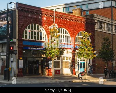
Out of Order again from my planned virtual sojourn but the present day Lambeth North station on the Bakerloo Line fascinates me. I should find some photos of the wider area , it stands on the south east section of a cross roads , facing off to the north east quadrant of Westminster Bridge Road one time Entrance to the London Necropolis Railway , and more recently the yard of London Duck (DUKW) Tours. My sources tell me the ox blood colour finished tiles over the essentially steel frame of the two storey building was designed by Leslie Green , but there are few of the embellishments some other stations contemporary on the line or the other UERL projects. Not pictured yet is the below ground level platforms nor tunnels , those to the south rather awkwardly leading to the London Road depot for the tube cars before leading to the terminal at Elephant and Castle. The two storeys were needed to house the lift gear mechanisms , other earlier stations had a dome on a single storey building to do the same ( examples might follow one year ) What threw me about the area was the building to the north which no longer exists I thought was a WW2 bomb damaged and demolition but that demolition appears to have come later, the building to the south didnt exist and looks a 1950s addition it is / was used by London Underground as training rooms for ticket office staff and others. ( The main London Transport theory training being over near Paddington Station at Griffin House , Marylebone.
North of the station the line went to Waterloo - I dont think it had an above ground building of substance being hidden under the platform concourse of the London and South Western Railway main London terminus.
Stock photo of the contemporary about todaytime frontage is
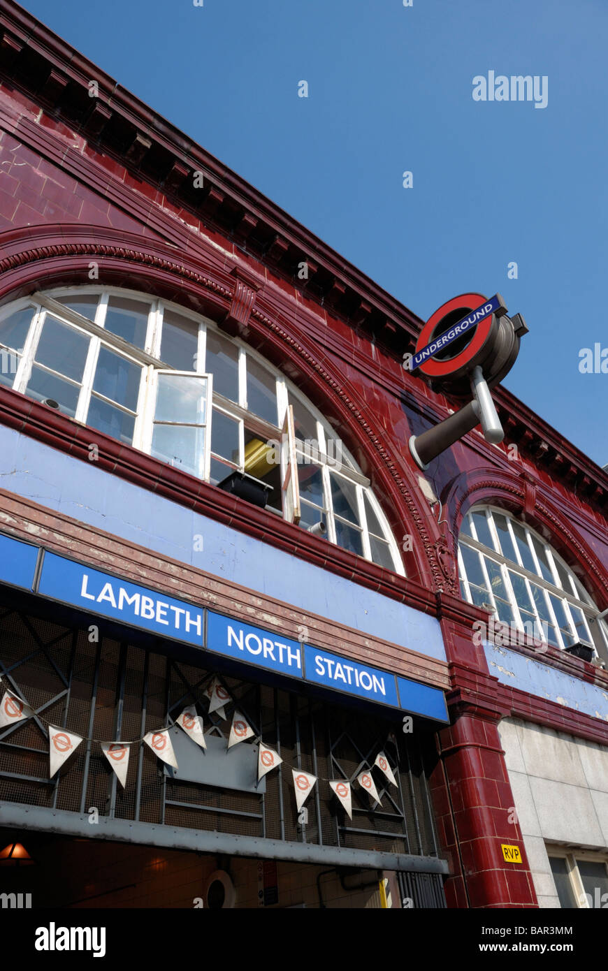
Stock view of a few years back during one of the significant anniversaries of opening of the line . Interesting and incongruous is the rather heavy steel or ali modern chunky UNDERGROUND roundel. The detail of the window arches can be seen with "keystone" central block and a running crimp pastry edge to the inner of the archway and adjoining arches meet in a decorative feature that echoes the arts and crafts of edwardian england , The plinth facings show the detail ( often found in public houses too normally in a more brown shade) and the square detail is interesting (has it got a name ?)
The station was opened as Kennington Road, Jul 1907 - Dec 1907. Renamed possibly to avoid confusion with Kennington on the City and South London Railway. I dont have photos of the station like that and its renaming of Westminster Bridge Road station is also rarely pictured

The entrance was on the south of the frontage with the exit on the north. Passenger numbers never reached expected ones and the exit and entrance were combined. The station may be in Zone 1 but it is an area of artisan terraces and 1950s flats . people work nearby and would have used the street trams or walked to their work - much in Waterloo Station itself or St Thomas Hospital and little to atract custom from elsewhere. I use it as handy for Lower Marsh market (less attractive now older designer 2nd hand shops and record dealers went into retirement) and the Oasis church centre. The BAKER STREET AND WATERLOO RAILWAY name in tiles is noticable and the building was designed to have office block additional storeys above. The shop to let indeed would eventually be let , as we shall see. Also of interest are the end iron outriggers - for a canopy or to carr advertising ? The same design is done as triangle forming 2 off pairs too . like some bakers sign that should read "HoVIS" which never arrived
 Aug 1930 and the building to the north is the ?North? Lambeth Building Society (this would move to the north east quadrant opposite in a 1950s festival pf Britain style. I was wrong of the building to the south as its brickness appears in this view
The shop is let to Angel Botibol and Co (which makes a change from Finlays that seemed to have a LNER railway monopoly) The underground vertical box and the maroon painted window bars we have seen before on other tube served buildings
 It is wartime in WW2 and some changes have occured. Why Angel Botibol have lost their name I dont know , Station has become generic with no place so invading Germans wont know where they are (did the same apply to the likes of Stockport , Earby or Barnoldswick?) Blast baffles were made of breeze block or at other places corrugated iron with poured concrete or a combination of both methods. I assume the whitewashing of windows was opaque enough to let sunlight in but not electric light out
I mentioned going north the line goes to Waterloo , it then heads under the River Thames , pulling in to Charing Cross tube station (now named Embankment) thence to Trafalgar Square (now renamed Charing Cross) . A problem in tunnels under the thams is the potential of inrush of water should a bomb or other thing damage the river bed and then the tunnel roof of the lines , particulary if the tunnels beyond under the thames run lower such that one or more stations could be flooded completely. Various sliding or similar doors were needed to be installed , including a need for water seal packing , which interestingly appear not to be rubber , asbestos or tarred hemp. but used manilla - something I should look up as a rope sealing product on the main doors and also ducts and similar.
 1953 and I cannot read the flagpole roundel name , but Lambeth (North) is now station name in a not quite corporate lettering style and Angel Botibol has returned with less flamboyant retail display
 1957 and I still cannot read what is on the roundel , Angel Botibol look to have ceased effective trading and it may be corporate station name but the whole frontage looks a mess. Looking more like an electricity substation the building to the south looks like it could win an award for the most amount of brick in a wall known to humaninty (I know of more which are substations in Ealing , west london)
My inspiration for this review was a YT of a Lego design for an underground railway which chose this as its design , which mentioned Leslie Green and it didnt look quite right to me - but it is so that is learning for me
North of the station the line went to Waterloo - I dont think it had an above ground building of substance being hidden under the platform concourse of the London and South Western Railway main London terminus.
Stock photo of the contemporary about todaytime frontage is
Stock view of a few years back during one of the significant anniversaries of opening of the line . Interesting and incongruous is the rather heavy steel or ali modern chunky UNDERGROUND roundel. The detail of the window arches can be seen with "keystone" central block and a running crimp pastry edge to the inner of the archway and adjoining arches meet in a decorative feature that echoes the arts and crafts of edwardian england , The plinth facings show the detail ( often found in public houses too normally in a more brown shade) and the square detail is interesting (has it got a name ?)
The station was opened as Kennington Road, Jul 1907 - Dec 1907. Renamed possibly to avoid confusion with Kennington on the City and South London Railway. I dont have photos of the station like that and its renaming of Westminster Bridge Road station is also rarely pictured
The entrance was on the south of the frontage with the exit on the north. Passenger numbers never reached expected ones and the exit and entrance were combined. The station may be in Zone 1 but it is an area of artisan terraces and 1950s flats . people work nearby and would have used the street trams or walked to their work - much in Waterloo Station itself or St Thomas Hospital and little to atract custom from elsewhere. I use it as handy for Lower Marsh market (less attractive now older designer 2nd hand shops and record dealers went into retirement) and the Oasis church centre. The BAKER STREET AND WATERLOO RAILWAY name in tiles is noticable and the building was designed to have office block additional storeys above. The shop to let indeed would eventually be let , as we shall see. Also of interest are the end iron outriggers - for a canopy or to carr advertising ? The same design is done as triangle forming 2 off pairs too . like some bakers sign that should read "HoVIS" which never arrived
Aug 1930 and the building to the north is the ?North? Lambeth Building Society (this would move to the north east quadrant opposite in a 1950s festival pf Britain style. I was wrong of the building to the south as its brickness appears in this viewThe shop is let to Angel Botibol and Co (which makes a change from Finlays that seemed to have a LNER railway monopoly) The underground vertical box and the maroon painted window bars we have seen before on other tube served buildings
It is wartime in WW2 and some changes have occured. Why Angel Botibol have lost their name I dont know , Station has become generic with no place so invading Germans wont know where they are (did the same apply to the likes of Stockport , Earby or Barnoldswick?) Blast baffles were made of breeze block or at other places corrugated iron with poured concrete or a combination of both methods. I assume the whitewashing of windows was opaque enough to let sunlight in but not electric light outI mentioned going north the line goes to Waterloo , it then heads under the River Thames , pulling in to Charing Cross tube station (now named Embankment) thence to Trafalgar Square (now renamed Charing Cross) . A problem in tunnels under the thams is the potential of inrush of water should a bomb or other thing damage the river bed and then the tunnel roof of the lines , particulary if the tunnels beyond under the thames run lower such that one or more stations could be flooded completely. Various sliding or similar doors were needed to be installed , including a need for water seal packing , which interestingly appear not to be rubber , asbestos or tarred hemp. but used manilla - something I should look up as a rope sealing product on the main doors and also ducts and similar.
1953 and I cannot read the flagpole roundel name , but Lambeth (North) is now station name in a not quite corporate lettering style and Angel Botibol has returned with less flamboyant retail display 1957 and I still cannot read what is on the roundel , Angel Botibol look to have ceased effective trading and it may be corporate station name but the whole frontage looks a mess. Looking more like an electricity substation the building to the south looks like it could win an award for the most amount of brick in a wall known to humaninty (I know of more which are substations in Ealing , west london)My inspiration for this review was a YT of a Lego design for an underground railway which chose this as its design , which mentioned Leslie Green and it didnt look quite right to me - but it is so that is learning for me