I make no apology for going back to the subject of drainage. The more we know about it the better any decisions to alleviate floods will be.
A friend of mine mentioned that 'Salterforth Lake', the pooling of water in the Bottoms to the west of Kelbrook, was bigger than he had ever seen it before. There is very little fall in that section of the valley and water doesn't get away easily towards Earby and the Aire Basin. You have to go back up the hill on to Whitemoor to fully understand the reasons why it is sometimes worse than others. Most of the water on Whitemoor drains eastwards but due to the contours of the land, swings sharply to the left after Barlick and heads off down into the Ribble catchment. However, funnily enough, the drainage from the west end of the moor heads down the hill, feeds what is now Whitemoor Reservoir and continues down into the valley past there via what we call County Brook but which used to be the Black Brook. It runs into Salterforth bottoms and if the flow is heavier than the fall in the valley can cope with it pools there.
When the canal was built at the end of the 18th century one of the reasons it was diverted northwards to include Barlick was that by doing so it could take advantage of the County Brook to supply the summit level of the canal. A canal is only as good as the supply of water to the summit level. Water let down from the reservoir runs into the canal just below County Brook Mill. On the opposite bank you can see some arched openings in the retaining wall above the valley. Any excess of water in the canal at this point flows over the cills and continues down the bed of the old Black Brook into the valley and the Bottoms.
When the canal was busy, water was continually drawn off at both ends of the summit level to operate the locks and so the amount of flow over the cills down towards Salterforth was limited and the drains in the valley and Earby could cope.
It is no accident that flooding at Lane Ends in Earby (The level crossing area) became more frequent as the levels of traffic on the canal decreased after the 1950s. Less water was used for the locks and more went down the hill towards the Bottoms. This is what has happened over the last few days, no leisure traffic on the canal because it is winter. more water running down the bed of the old Black Brook and eventually more weight of water in the bottoms and Earby.
The canal is an essential component of the drainage system and these arches in the bank are a good example. If you weren't looking for them you could easily miss them but they are an important factor in water levels in the valley. Definitely a forgotten corner!
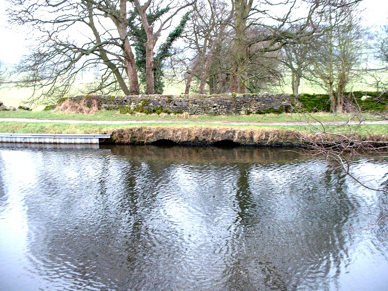
The overflow arches on the canal at County Brook.