THE BOWKER DRAIN

User avatar
Stanley
Global Moderator
Global Moderator
Posts: 91722
Joined: 23 Jan 2012, 12:01
Location: Barnoldswick. Nearer to Heaven than Gloria.

THE BOWKER DRAIN

Post by Stanley »

THE BOWKER DRAIN

Yes, it's one of my Golden Oldies cropping up again. As many of you will know, the Bowker Drain has fascinated me for years, it starts near Kelbrook New Road in the meadow on the east side of the canal and follows the line of the canal to Barnsey where it goes under Long Ing Shed and the foundry, along Eastwood Bottoms, under Crow Nest cottages, through the car park for Bankfield Shed and discharges into the Stock Beck on the east side of the footbridge into Victory Park. It's flow has varied over the years because of changes upstream like the canal being made less prone to leaks and the water being drawn off it at various points but it is still a major watercourse even today.
What's brought it up again is the Boxing Day floods which at long last has triggered renewed enquiry into water flows in the town and how they can best be managed to protect us from flood damage. David Whipp is very active in these matters and as he knew of my interest in these esoteric matters he's been absorbing anything I can tell him and passing it on to the decision makers. Who says that historical research is superfluous to requirements in these modern times!
The thing that has intrigued me over the years is that despite its obvious importance, for instance it was water drawn off the Bowker Drain in Eastwood Bottoms that supplied Wellhouse Mill with all that it needed for over 100 years, every time I started asking questions about it people clammed up. Harold Duxbury knew a lot about it but when I taxed him he would just lay his finger alongside his nose and smile at me. When I was doing my Local History class one of the older members told me that he remembered walking along the side of the canal with his grandfather when he was a lad and had a flagstone in the field pointed out to him with the injunction “If ever you want some water for nowt, take it out of that drain!” and he'd always wondered what it was all about. Water is an embarrassment now but 200 years ago it was a valuable resource for driving water wheels and supplying steam engines with the coolant for the economisers on the engines that were essential for economical running. That's why ownership of riparian rights on water courses was so important and was the reason why it was a topic of interest to so many people.
With the decline of the necessity for water for manufacturing these matters started to fade into distant memory but now, because of different pressures, they are becoming important again. That's why I have been banging on about water this year and have little doubt I shall be returning to it. So, when you open your paper and realise that Stanley is on about water again, recognise that the wider any knowledge I have is spread, the less chance there might be of you getting flooded out!

Image

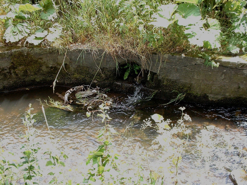
This is the exit of the Bowker Drain into Stock Beck.
Stanley Challenger Graham
Stanley's View
scg1936 at talktalk.net

"Beware of certitude" (Jimmy Reid)
The floggings will continue until morale improves!
David Whipp
Senior Member
Posts: 2874
Joined: 19 Oct 2012, 18:26

Re: THE BOWKER DRAIN

Post by David Whipp »

Was it built by someone called Bowker?

My first interest in the Bowker Drain didn't involve flooding; it was when residents in the area expressed concern about children in the area laking about with the open concrete cover in Eastwood Bottoms. I guess this is something that Ian may be familiar with...
User avatar
PanBiker
Site Administrator
Site Administrator
Posts: 16647
Joined: 23 Jan 2012, 13:07
Location: Barnoldswick - In the West Riding of Yorkshire, always was, always will be.

Re: THE BOWKER DRAIN

Post by PanBiker »

The drain runs along the back of what used to be the allotments down Havre Park. My dad had one of these. The drain was open the full length of the allotments and was used as required as a watering source in conjunction with rainwater gathered in butts from the run off from greenhouses and sheds. Only problem was it had to be carried through two other plots to my dads patch. Many an afternoon spent bucketing water from the beck to the allotment, especially in the run up to early and late horticultural shows in the town, lack of water was not an option when prize tomatoes, spuds beans and onions had to be produced. Not to mention mums Chrisant's and Sweet Williams.
Ian
David Whipp
Senior Member
Posts: 2874
Joined: 19 Oct 2012, 18:26

Re: THE BOWKER DRAIN

Post by David Whipp »

Thanks Ian.

There may be some confusion about the watercourses in that area... I think the one you mention is tributary of Crow Nest Syke. This is vaguely parallel to the Bowker Drain and is on the surface at the end of the allotments.

This takes the water falling on the land on the town side of the high school. In the land off Clifford Street, it runs in a stone culvert (in a questionable state of repair...). Still culverted, it runs down besides Langsford Close and then Rakes Cottage. It then crosses Long Ing at the bottom of Rainhall Road in an old culvert. The watercourse then has a bit of a treat; when Coronation Street and Clayton Street had an 'enveloping' scheme carried out around the early '90s, Pendle Council took the opportunity to renew and upsize the culvert as it runs along the gable ends of these streets.

I believe the watercourse then emerges into the open air between what is now Scothern Close (the new houses off Valley Road) and the long gardens at the rear of Long Ing Lane, before turning ninety degrees and running behind Scothern Close. It then runs alongside the remaining allotments at the gable end of Havre Park and Ethel Street. It then goes back into culvert beneath the parking/service area for the small industrial units at Crow Nest and then joins the main branch of Crow Nest Syke alongside Ouzledale foundry. (This part of the syke emerges from beneath Long Ing Mill from I know not where.)

The combined flow runs alongside Ravenscroft Way and back into culvert. (Going back 15/20 years, it was blockages at this point that caused this area to flood, threatening the lowest properties on Edward Street with flooding. One problem was the culvert entrance becoming blocked; this has been sorted out by installing a new trash screen and having it cleared regularly. The second issue was the culvert itself being inadequate under what is now the Spar garage. This was sorted out by getting contributions from various developments in the area, together with the borough and county councils, and renewing and upgrading that section.) The watercourse then goes down Crow Nest Road in a pipe installed sometime in the 1950s/60s I guess.

This section is a diversion from the original route, which runs alongside Skipton Road to what was Windle's Garage (Vicarage Motors now), underneath Skipton Road and Crow Nest Mill and into the mill lodge. This section is in very poor condition; it's presumed that the diversion down Crow Nest Road was installed because of this.

The syke discharges into Stocks Beck at the bottom of Crow Nest Road. A little further downstream is where the Bowker Drain comes into Stocks Beck. The drain is further east than Crow Nest Syke. Apart from when Eastwood Bottoms flood, it's not connected with Crow Nest Syke.

A further snippet about watercourses in that area is that there used to be a ditch that took the water from the vicinity of Rakes Cottage along the line of what is now Valley Road. I'm told this fed into a lodge which presumably served Wellhouse Mill, or did the foundry have a lodge?
User avatar
PanBiker
Site Administrator
Site Administrator
Posts: 16647
Joined: 23 Jan 2012, 13:07
Location: Barnoldswick - In the West Riding of Yorkshire, always was, always will be.

Re: THE BOWKER DRAIN

Post by PanBiker »

I had an idea it might not have been the same watercourse, all is clear now, thanks for that. For Wellhouse mill I can confirm there was a mill dam as I recently mentioned in another thread. Behind the mill shed which had a sluice along the back wall for the condensate run off I assume. Far side of the dam from the mill was Bill Craddocks Farm and fields at the end of Vicarage Road. I first learnt to drive in Bills Land Rover in the field when I was about 12 years old or so. I and a mate used to do odd jobs around the farm with the pigs and chickens and the like. Mill dam was quite idyllic and workers from the Skipton Road end of Wellhouse, (was it Rolls or Brown and Pickles in the 60's) used to come to the far side of the dam for a fag on their breaks. It had loads of decent sized goldfish, sticklebacks, bulrushes, water lilies, moorhens and a nesting pair of swans. It was at the back of the garages and was eventually tipped on with landfill. More or less where the P.O. Sorting Office is now.
Ian
User avatar
Wendyf
Global Moderator
Global Moderator
Posts: 9523
Joined: 23 Jan 2012, 12:26
Location: Lower Burnt Hill, looking out over Barlick

Re: THE BOWKER DRAIN

Post by Wendyf »

"A further snippet about watercourses in that area is that there used to be a ditch that took the water from the vicinity of Rakes Cottage along the line of what is now Valley Road. I'm told this fed into a lodge which presumably served Wellhouse Mill, or did the foundry have a lodge?"

You can see the drain quite clearly on this 1st edition OS map, taking a sharp right turn to join Crow Nest Syke.

Image

By the 1890's, as you can see from THIS side by side view, it must have been covered over and would possibly feed directly into the Wellhouse Mill Lodge.
User avatar
PanBiker
Site Administrator
Site Administrator
Posts: 16647
Joined: 23 Jan 2012, 13:07
Location: Barnoldswick - In the West Riding of Yorkshire, always was, always will be.

Re: THE BOWKER DRAIN

Post by PanBiker »

Image does not look to be in the gallery Wendy.
Ian
User avatar
Wendyf
Global Moderator
Global Moderator
Posts: 9523
Joined: 23 Jan 2012, 12:26
Location: Lower Burnt Hill, looking out over Barlick

Re: THE BOWKER DRAIN

Post by Wendyf »

Oh, it was there earlier! I'll have another go.
User avatar
Wendyf
Global Moderator
Global Moderator
Posts: 9523
Joined: 23 Jan 2012, 12:26
Location: Lower Burnt Hill, looking out over Barlick

Re: THE BOWKER DRAIN

Post by Wendyf »

I've uploaded it again. Definitely there now....I'll keep an eye on it!
User avatar
Stanley
Global Moderator
Global Moderator
Posts: 91722
Joined: 23 Jan 2012, 12:01
Location: Barnoldswick. Nearer to Heaven than Gloria.

Re: THE BOWKER DRAIN

Post by Stanley »

Interesting stuff and thanks to you all for taking an interest. David, I think that the name Bowker must be from the person who originally installed it but I have no idea what his connection was. I suspect the Drain was originally installed for the sole purpose of providing water for the lodge that served Old Coates mill c.1800. This was of course the time the canal was being constructed. There is a culvert (culverts) under the canal to get the water from Bob Preston's meadow opposite LPM into the drain on the marina side. I've seen a plan marked 'Two oak baulks' at that point and assume that the canal company made that provision because otherwise the bottom of Bob Preston's would have flooded and the landowner (Far Hey Farm) would have had a claim against the company.
There is of course the possibility that there was a drain in there before this time as otherwise all that land down the valley would have been waterlogged.
As far as I know the Bowker Drain is fully culverted all the way from the gravel bed near Kelbrook New Road to what was the Old Coates Lodge. There used to be an access manhole between the old and new sheds at Long Ing Shed. There was another access in Moss Mill Yard and Moss used to 'steal' water from there when they needed it. Walt Fisher's father ran the engine and he told Walt that after the canal made improvements to stop leakage in the 1950s much less water flowed into the drain.
I have a theory that when Bracewell built Wellhouse Mill in 1853 he knew about the Bowker Drain and at the time old Barlickers were puzzled by the fact he was building there because there was no evident viable water supply for the mill, if my memory serves, Atkinson mentions this in 'Old Barlick'. He never attempted to use Crow Nest Syke but relied on the Bowker Drain from the start. Harold Duxbury investigated the overflow from the lodges at Wellhouse and found that it was piped directly to the Stock Beck at a lower level than Old Coates dam, Harold and I agreed that it looked as though he was deliberately denying the water to his cousins at Old Coates. Totally in character! Harold thought it was a 6" cast iron pipe.
Incidentally, Bracewell put another 6" CI pipe in from the new lodge at the Corn Mill to Wellhouse. He controlled the Corn Mill at that time and built the larger lodge which is now a garage site. See the CHSC minute books for evidence that this exists because they considered using the water at one time but never took it. I think because they didn't want to rely on water that wasn't under their control. Instead they sank a well 186ft deep near the lodges, see the minute books again for a full account of this. The well was not a success and was never used. The incentive for going to these lengths was that Roundells at Gladstone owned Eastwood Bottoms and at one point raised the price for access and again, the directors were worried about losing control of the supply, in effect being blackmailed. The well would have made them totally independent.
I think you can see why this has fascinated me for years.......
Stanley Challenger Graham
Stanley's View
scg1936 at talktalk.net

"Beware of certitude" (Jimmy Reid)
The floggings will continue until morale improves!
David Whipp
Senior Member
Posts: 2874
Joined: 19 Oct 2012, 18:26

Re: THE BOWKER DRAIN

Post by David Whipp »

Thanks for all the additional information.

The land at the bottom of Bob Preston has a drain that takes water down towards Salterforth; I think this is part of the Earby and Salterforth Internal Drainage Board area.

An interesting detail on the first edition OS map is the 'Sandstone Quarry'. On the opposite side of the canal, the underlying rock is limestone.

Is this either side of the Craven Fault? Anyone know just where the fault line is around there?
User avatar
Wendyf
Global Moderator
Global Moderator
Posts: 9523
Joined: 23 Jan 2012, 12:26
Location: Lower Burnt Hill, looking out over Barlick

Re: THE BOWKER DRAIN

Post by Wendyf »

Ken Ranson has sent me this about Thomas Bowker, Cotton Manufacturer.

Extract from Old Barlick - W.P.Atkinson

“1887. The first important company venture in Barnoldswick, Coates Old Shed excluded was the Long Ing Shed erected at first for 1,188 looms and divided into three sections of 396 looms each, and soon afterwards extended for another 481 looms, whilst more recently another extension has taken place, thus bringing the total loom space up to 2,009. (including 274 large sheeting looms) These premises were at first occupied by T S Edmondson (and James Nutter for a short while) Mr E Ormerod, Mr J Brown, Mr T Bowker, Messrs. Eastwood and Maudsley, and Messrs. Holden Brothers the majority of whom have passed away.

1891 census Thomas Bowker cotton manufacturer
User avatar
Wendyf
Global Moderator
Global Moderator
Posts: 9523
Joined: 23 Jan 2012, 12:26
Location: Lower Burnt Hill, looking out over Barlick

Re: THE BOWKER DRAIN

Post by Wendyf »

Another message from Ken re the limestone fault:-

When I was at Rolls I was involved with the building of the large green tin buildings at the bottom of Bankfield shed next to Greenberfield Lane. The building had to be piled to a great depth because of this fault. Just talked to the guy who built the building he says the fault runs through Bankfield, Coates and on through Salterforth. His dad built Coates estate and he had lots of problems.
User avatar
PanBiker
Site Administrator
Site Administrator
Posts: 16647
Joined: 23 Jan 2012, 13:07
Location: Barnoldswick - In the West Riding of Yorkshire, always was, always will be.

Re: THE BOWKER DRAIN

Post by PanBiker »

David Whipp wrote:
Is this either side of the Craven Fault? Anyone know just where the fault line is around there?
The nearest fault line is the Southern Craven Fault which runs East to West through Gargrave. Barlick sits on the Southern side of this fault line. If you google Craven Fault you can get various maps of the North and South fault lines and the area known as the Mid Craven Fault.
Ian
User avatar
Stanley
Global Moderator
Global Moderator
Posts: 91722
Joined: 23 Jan 2012, 12:01
Location: Barnoldswick. Nearer to Heaven than Gloria.

Re: THE BOWKER DRAIN

Post by Stanley »

The mid Craven Fault has always interested me. All the quarries on the East side of Barlick including Rainhall Rock, were limestone. You can get an idea of how quickly it changes by the fact that there is a limekiln at Hollins but not far away across the fields you have the good sandstone of Tubber Hill. The limekiln at the bottom of Bob Preston's is a bit of a tease because it would be using limestone from Rainhall Rock. The railway used Rainhall stone, have a look at the big retaining wall in the Pioneer car park. At the time the canal was built there was a big demand for Barlick limestone in East Lancashire because the nearest to them was the old coral reefs around Clitheroe and the canal gave much easier access to supplies, 40 tons per boat load. Beat road transport hands down!
I knew about Bowker at Long Ing but while he has the same name he is too late to be the Bowker who built the drain. I suspect that it was put in, or existed at least, in the late 18th century.
Stanley Challenger Graham
Stanley's View
scg1936 at talktalk.net

"Beware of certitude" (Jimmy Reid)
The floggings will continue until morale improves!
User avatar
plaques
Donor
Posts: 8094
Joined: 23 May 2013, 22:09

Re: THE BOWKER DRAIN

Post by plaques »

A slight diversion if I may. The Anchor Inn in Salterforth is well known for its limestone stalactites in the cellar. It is said that these are the result of the old Inn being partially buried under the line of the canal. The limestone seepage is supposedly from the canal bedding. This raises a question of logistics. Was the limestone carried overland from some distant source or was there a supply nearer to the canal itself? One could also ask why use limestone if there were sandstone quarries at hand?
David Whipp
Senior Member
Posts: 2874
Joined: 19 Oct 2012, 18:26

Re: THE BOWKER DRAIN

Post by David Whipp »

More interesting material...!

Something that's been so obvious that I've overlooked it, is the name of the watercourse that I've been describing as a tributary to Crow Nest Syke (and which Ian thought was the Bowker Drain); this will be Rakes Beck?

P; the height of the road was lifted next to the Anchor to get the bridge over the canal. The inn was extended upwards. Maybe limestone was more accessible for the building?
User avatar
Wendyf
Global Moderator
Global Moderator
Posts: 9523
Joined: 23 Jan 2012, 12:26
Location: Lower Burnt Hill, looking out over Barlick

Re: THE BOWKER DRAIN

Post by Wendyf »

This might help. Geology of Britain viewer
User avatar
Wendyf
Global Moderator
Global Moderator
Posts: 9523
Joined: 23 Jan 2012, 12:26
Location: Lower Burnt Hill, looking out over Barlick

Re: THE BOWKER DRAIN

Post by Wendyf »

We have drifted away from the Bowker Drain, but that geological map is fascinating!
The bright blue blob of limestone just left of centre is the bottom section of my field....the only part that drains well and provides a bit of winter grazing for the ponies. The rest of the field is on shale over gritstone and turns to a spongy mess every autumn.

Image
User avatar
PanBiker
Site Administrator
Site Administrator
Posts: 16647
Joined: 23 Jan 2012, 13:07
Location: Barnoldswick - In the West Riding of Yorkshire, always was, always will be.

Re: THE BOWKER DRAIN

Post by PanBiker »

Rainhall, Ghyll and Thornton quarries stand out on the map as does the one at Hollins the deposits there are lot bigger than the workings look to have exploited.
Ian
User avatar
Tizer
Global Moderator
Global Moderator
Posts: 18953
Joined: 23 Jan 2012, 19:46
Location: Somerset, UK

Re: THE BOWKER DRAIN

Post by Tizer »

As Ian notes, the Craven faults are north of Barlick.
David, a sudden change on the ground from, say, sandstone to limestone doesn't mean it must be a fault line. If you have one type of rock bedded on top of another and they lie at an angle from the horizontal then erosion will result in both layers of rock being exposed at some point, thus giving a sharp change. Similarly, if they are horizontal, then river or glacial erosion will cut through and expose the join between the two layers. These joins are known as `contacts'. On the other hand, faults are where one rock moves in position relative to another. They often occur within one type of rock rather than between different types and then you have the same type of rock on both sides of the fault.
Nullius in verba: On the word of no one (Motto of the Royal Society)
User avatar
Nolic
Senior Member
Posts: 1027
Joined: 23 Jan 2012, 12:10
Location: Barrowford

Re: THE BOWKER DRAIN

Post by Nolic »

Simple questions and forgive me if I have missed them. Who built the Bowker Drain, why and when? Nolic
"I'm a self made man who worships his creator." Image
User avatar
plaques
Donor
Posts: 8094
Joined: 23 May 2013, 22:09

Re: THE BOWKER DRAIN

Post by plaques »

Thanks Wendy. The geology map explains it all. There is a small limestone area just at the Anchor Inn point. One thing less to ponder over.
User avatar
Stanley
Global Moderator
Global Moderator
Posts: 91722
Joined: 23 Jan 2012, 12:01
Location: Barnoldswick. Nearer to Heaven than Gloria.

Re: THE BOWKER DRAIN

Post by Stanley »

Comrade, it's complicated. It was an important water source for the mills in Barlick. You'll have to read the topic .....
Stanley Challenger Graham
Stanley's View
scg1936 at talktalk.net

"Beware of certitude" (Jimmy Reid)
The floggings will continue until morale improves!
David Whipp
Senior Member
Posts: 2874
Joined: 19 Oct 2012, 18:26

Re: THE BOWKER DRAIN

Post by David Whipp »

I may have asked this before... is there a plan showing where the Bowker Drain goes under the canal?
Post Reply

Return to “Stanley's View”