A friend of mine is doing some ground-breaking work using the latest LIDAR imaging of the area. This is a technique that 'sees' through vegetation and gives a very accurate picture of the smallest features on the ground. He noticed some traces of old watercourses at Sough and asked me to comment.
The first thing to do is look back to what I had to say about County Brook last week and the 'Salterforth Lake'. There is very little fall on the water coming down from Salterforth Bottoms through Sough. (The name is the clue here!) I have little doubt that it was a very swampy piece of ground. The problem was so bad that in the early part of the 19th century the Salterforth electors and others joined together to find a solution. I had an idea there was a Drainage Act but couldn't find a reference. However, this extract from the Craven Herald of 22/07/1938 is enlightening:
"Evidence of Mr John Edmondson, Skipton Road, whose father and grandfather occupied the White Lion Inn. About a century ago the low lying ground between Foulridge and Earby was a veritable swamp for most of the year and near Salterforth it was known as 'Salterforth Lake'. A Drainage Board was appointed by Government Commissioners and they met in the vestry of Thornton in Craven church. Four drains were made called Kelbrook Bottoms Drain, Earby Holmes Drain, Stone Trough Drain and Lancashire Gill Drain. The reclaimed land on either side of the main stream was allotted to the neighbouring farms. From Sough Bridge to Earby, on the East side, one field went to Tunstead Farm and the next field to Moor Hall Farm. The second field from the Earby end was formerly in two parts one of which belonged to the White Lion Inn and the other to John O' Dick's Farm. The first field at the bottom of Langroyd Lane belonged to the Waddington Fold Farm and was called 'Wadd Holme'. The Kelbrook portion was known as Kelbrook Bottoms and the Earby section as Earby Holmes. The fields on the West side of the beck were mostly allocated to White House Farm."
Bear in mind what I said last week about the alterations to water flows made during the construction of Whitemoor reservoir in 1840. I don't think it is a coincidence that this initiative cropped up at the same time. In a nutshell, the whole of the drainage system from Salterforth Bottoms to Earby was opened up and improved and I think that the LIDAR traces on the map of Sough are the course of the original watercourse which was re-cut, straightened out and improved to get better flow around 1840. I've just looked on the First edition OS (1853) and the realigned watercourse is shown and given the name 'New Cut'.
You see! History can be useful! When you see the New Cut in spate now you know where the water is coming from and why.
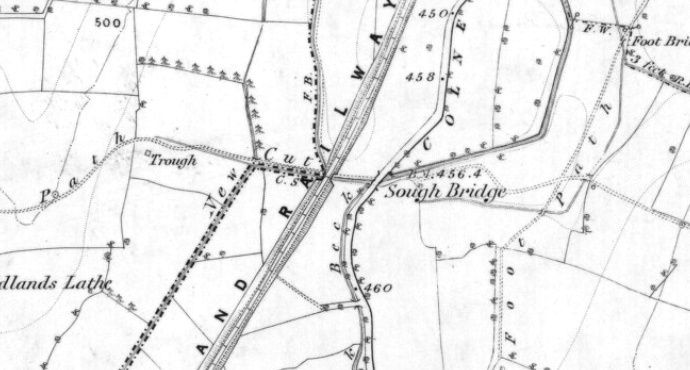
The New Cut at Sough speeding the water down to Earby.